


Carbon Storage Atlas
- Why this Location
- Main Research Q&As Discovered
- Lessons Learned
- Field Site Story of Interest
- Geologic Details
- Sites
Lat/Long
Aneth Field, Utah: 109°16’45"W 37°18’3"N.
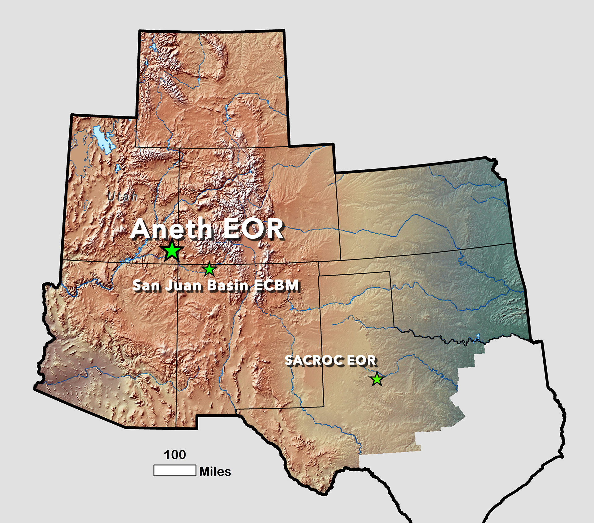
Aneth Field, located in southeastern Utah in the southern part of the Paradox Basin.
Why this Location
Following the Phase I carbon dioxide (CO2) source and sink assessment, the Southwest Regional Partnership on Carbon Sequestration (SWP) identified the most tenable storage options for its pilot phase: utilization of CO2 for enhanced oil and gas extraction. The Aneth Field in Utah was chosen as a pilot project to identify the differences and similarities to the historically successful Permian Basin enhanced oil recovery (EOR) (the Scurry Area Canyon Reef Operator’s Committee [SACROC] Unit), a separate SWP pilot project, and to use that information to develop a blueprint for commercial-scale carbon capture and storage (CCS)/carbon capture, utilization, and storage (CCUS) in the entire region. The Aneth Field lies in the Paradox Basin of the Colorado Plateau, which is characterized by its unique “layer cake” geology of alternating permeable and impermeable strata with significant potential for CO2 storage. Not only would the Aneth Field project allow for a contrast to the typical Permian Basin geology, but it would also allow SWP to investigate the properties of a field undergoing initial CO2 injection; the SACROC Unit has been injecting CO2 since 1972.
Main Research Q&As Discovered
The Aneth Field, Paradox Basin, Utah, is an archetypal oil field within the Colorado Plateau, a region with a large potential for carbon capture and storage (CCS)/carbon capture, utilization, and storage (CCUS). The Southwest Regional Partnership on Carbon Sequestration (SWP) utilized the Aneth Field project to: (1) identify the properties of carbon dioxide (CO2) injection and storage within the unique geology of the Colorado Plateau; (2) better understand CO2 enhanced oil recovery (EOR) from a historically underperforming oil reservoir; and (3) develop site characterization, modeling, and monitoring, verification, and accounting (MVA) activities that could be applicable to other CCS/CCUS sites within the Southwestern United States.
The geology of the Paradox Basin and greater Colorado Plateau is characterized by high-porosity, high-permeability reservoirs alternating with thick, low-permeability sealing units. The Desert Creek limestone/dolomite reservoir and the Gothic Shale seal are typical of Pennsylvanian and older sedimentary units in the region. While not representing the bulk of the CO2 storage potential in the region (i.e., Jurassic sandstone saline aquifers), these older units do contain extensive hydrocarbon resources that would benefit from availability of CO2 for enhanced recovery.
Extensive site characterization of the Aneth Field geology confirmed injectivity, mobilization of reservoir oil, and CO2 storage capacity of the reservoir rocks, as well as the sealing potential of the shales. It also identified heterogeneities and structures that could limit the efficiency and/or effectiveness of CO2-EOR operations in the field. Indeed, reservoir models and flow simulation activities suggest that CO2 injection rates for the Desert Creek carbonates of the Aneth Field cannot exceed approximately 0.25 million metric tons per year. Confirmation of the limits on CO2 injection rate came indirectly through passive seismic monitoring, where water injection in the field was correlated to “critically stressed” faults and associated microseismicity. Because of the heterogeneities and injectivity issues within the Desert Creek reservoir, simulation results indicate that horizontal wells with water alternating CO2 (WAG) are the most effective means of recovering 534 million barrels of the original oil in the field.
Lessons Learned
The experience and results obtained from the Aneth Field enhanced oil recovery (EOR) project had a positive impact on the Phase III EOR project at the Farnworth Unit, Texas. Foremost, the Southwest Regional Partnership on Carbon Sequestration (SWP) discovered that it is important to have significant stakeholder “buy-in,” primarily by the operator/owner of any field where carbon dioxide (CO2) injection may occur. At Aneth, this buy-in was manifested by Resolute Energy’s interest in expanding its CO2-EOR operations to the western half of the field and better understanding the EOR efficiencies through expanded site characterization; modeling/simulation; and monitoring, verification, and accounting (MVA) efforts. Particularly when it comes to industry, it can be exceedingly difficult to persuade a company to perform any activity unless there is an increased profit margin.
Story of Interest
The Aneth Field pilot study utilized a number of monitoring activities to aid in identifying carbon dioxide (CO2) migration within and beyond the injection reservoir. Passive seismic monitoring was deployed, via a borehole geophone array, to map pressure fronts and faults and to identify potential leakage pathways. For the duration of the Southwest Regional Partnership on Carbon Sequestration (SWP) project, the dedicated monitoring borehole geophone array detected few events near the wellbore or adjacent wells, probably because the area had been undergoing waterflood and saltwater disposal for many years prior to installation. However, small events (-1 to -3 on the Richter scale) were detected near the edges of the Desert Creek reservoir, where it thins and pinches. The majority of microseismic activity was detected beneath the Desert Creek reservoir, more than 1 kilometer (~.62 miles) from the seismic monitoring well. The location of these events occurred along two NW-SE trends that were interpreted to be previously unmapped/unknown faults that were reactivated due to pressure increases from injection activities. While the source of the pressure increase was from a saltwater disposal well in the field, the injection can be considered an analog for any fluid injection at a carbon capture and storage (CCS)/carbon capture, utilization, and storage (CCUS) site, including CO2.
Geologic Details
The Aneth Field, Utah, is within the Paradox Basin (southeastern Utah, southwestern Colorado) of the Colorado Plateau region. The Paradox Basin formed during the Uncompahgre Uplift, which created a shallow sea closed to significant circulation. The Pennsylvanian Paradox Formation is characterized by interbedded shales, dolomites, anhydrite, and halite. The Aneth Field is composed of carbonates (dolomites) that developed in the shallow margins of the Basin and organic-rich shales from the deeper waters of the basin. The deeper shales are the source of the hydrocarbons in the basin, which migrated to the more permeable carbonate units – the current oil reservoirs. The Paradox Formation is overlain by more than 1,524 meters (5,000 feet) of Permian and younger carbonates, sandstones, and shales.
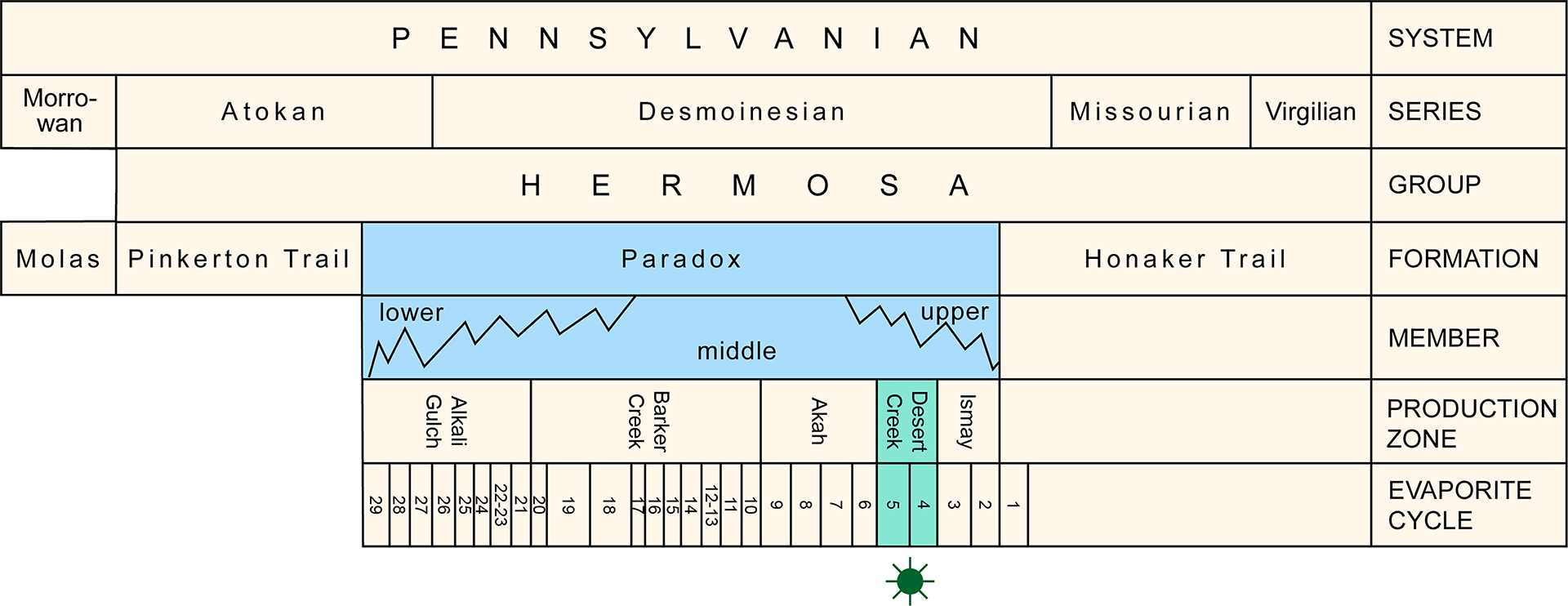
Stratigraphic column for the Paradox Basin, Utah. The Desert Creek Unit is the main oil-producing and CO2-injection reservoir within the Aneth Field, a Southwest Regional Partnership on Carbon Sequestration (SWP) Phase II Pilot site.
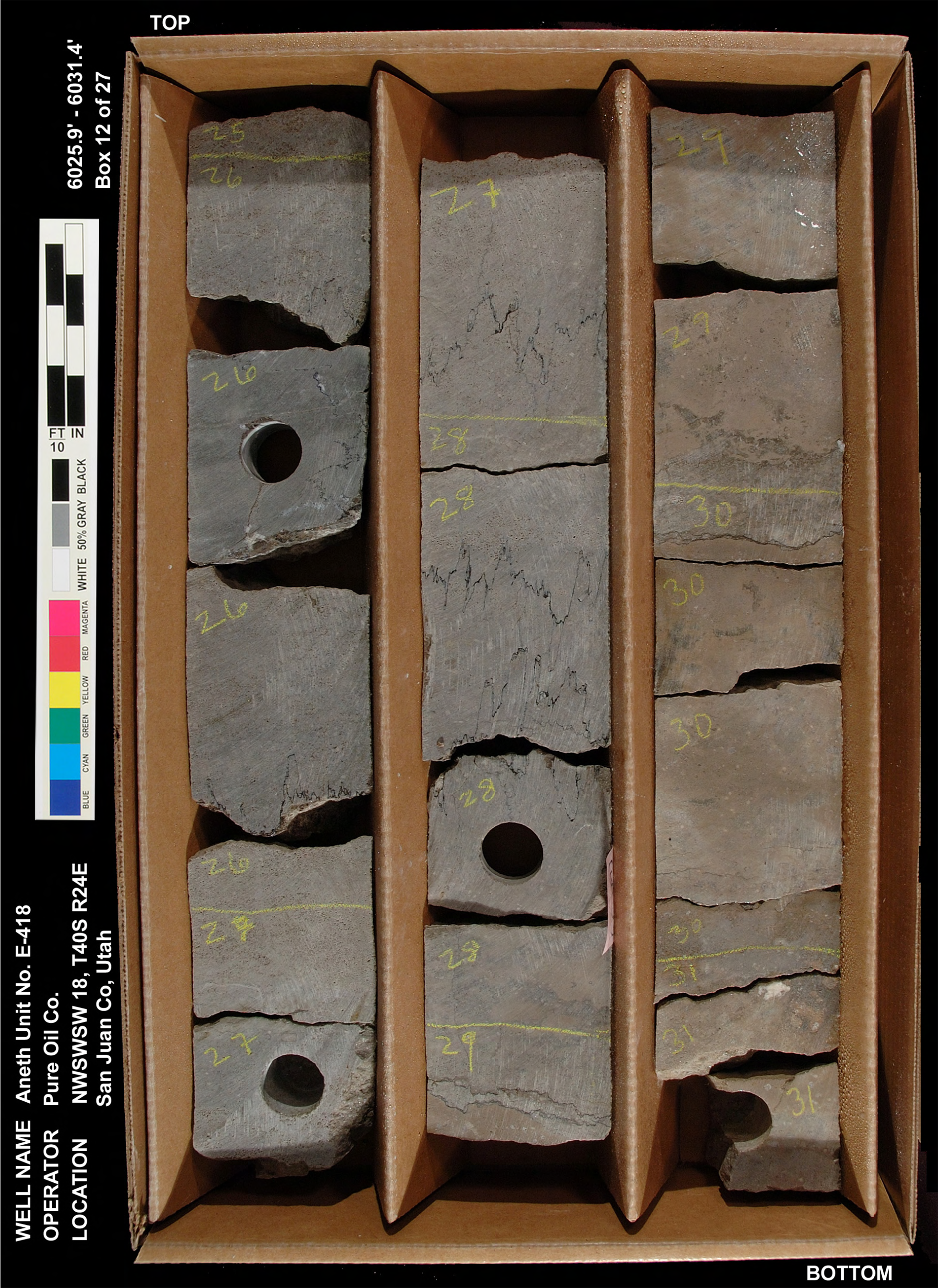
Slabbed core photo of the Desert Creek limestone unit from an oil well in the Aneth Field, Utah.