
Business

Business
The purpose of the project is to develop and test a novel technology designed to enhance seismic resolution and image quality using wave-equation depth migration and wave-equation velocity model building.
3DGeo
Location:
Houston, Texas 77084
Onshore and offshore Gulf Coast
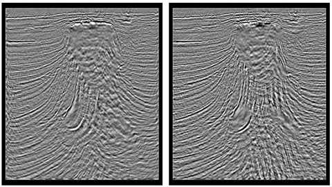
Oil and gas companies use seismic imaging to visualize the shape and complexity of a reservoir prior to drilling a well. The current technologies for depth imaging are the Kirchhoff pre-stack depth migration and the wave-equation depth migration. Wave equation methods are potentially more accurate and robust because they incorporate the full 3-D wave equation rather than being based on 2-D ray theory. The current project develops the ability to image deep gas prospects in onshore and offshore areas of the Gulf coast by using wave equation migration to handle multiple arrivals, and using a wider acquisition aperture (10-15 km) to optimize image quality for depths greater than 15,000 feet.
The potential impact of the project will be to allow better imaging of deep onshore and offshore plays that contain large volumes of undiscovered oil and gas. The Mineral Management Service (MMS) estimates that there are 193 Tcf of undiscovered, conventionally recoverable natural gas in the deeper sediments of the Gulf of Mexico. This technology will enhance industry’s ability to locate and develop this resource.
As of September 2005, 3DGeo had completed a set of algorithms to optimize pre-stack time migration and wave-equation velocity model building. In October 2005 3DGeo took delivery of PGS Onshore’s ultra-deep POC2 line that spans the onshore and offshore portion of the Texas gulf coast. The processing team began running iterations of the algorithms developed during the first year of the project, using the POC2 vibroseis/airgun dataset. In January 2006, 3DGeo began testing a true-amplitude imaging algorithm that improves the clarity of deep and steeply dipping events, conducting a series of tests to validate the algorithms developed.
This project has been completed and the final report is listed below under "Additional Information".
$504,944
$130,236
NETL – Frances Toro (frances.toro@netl.doe.gov or 304-285-4107)
3DGeo – Alexander Mihai Popovici (mihai@3Dgeo.com or 281-579-9712 x103)
Final Report [PDF-3.50MB]

