
Business

Business
The overall objective of the project is to establish a field laboratory and utilize a horizontal well of opportunity to conduct a scientific study designed to advance the understanding of the petrophysical and geomechanical properties of the Rogersville Shale. These properties will improve well completion design, ultimately leading to commercial production and the acceleration of play development.
University of Kentucky (UKY)/Kentucky Geologic Survey (KGS), Lexington, KY 40506
West Virginia University (WVU), Morgantown, WV 26506
West Virginia Geological and Economic Survey (WVGES), Morgantown, WV 26508
Hay Exploration, Ashland, KY 41101
Schlumberger, Houston, TX 77042
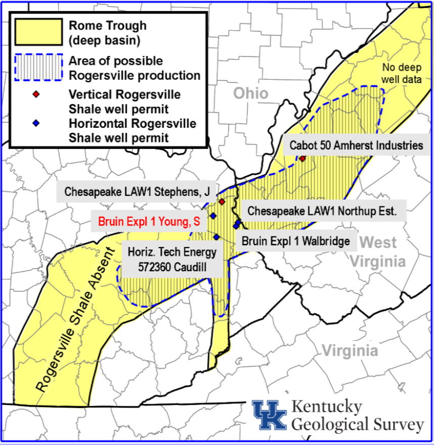
In 2013, the Bruin Exploration #1 Young well in Lawrence County, Kentucky, was the first well to target the Cambrian Conasauga Group shales as an unconventional oil and gas reservoir. Speculation on the success of this well quickly spread through the industry, resulting in a 2014 and 2015 regional oil and gas leasing boom across eastern Kentucky and southwestern West Virginia. Since 2013, five additional Conasauga shale wells have been drilled. Although most of these wells encountered oil and/or gas, the volumes produced during testing were lower than expected. Although the play appears to be a technical success, the economics of the play remain to be proven.
The Conasauga Shale Research Consortium (CSRC) intends to accelerate the development of the
Rogersville Shale and other Conasauga shales as unconventional oil and gas (UOG) plays by gathering
the additional data necessary, and testing different well completion designs in both theoretical models and
in a real-world application at an extended horizontal well drilled in Lawrence County, KY. Analyses will include evaluating the source rock’s (Rogersville Shale) thermal maturity, organic content, lithologic content, provenance of the clays within the unit, major- and trace-elemental analysis, scanning electron microscope (SEM) analysis of pore types, traditional and noble gas geochemistry of oil and/or gas that is produced, molecular and isotopic chemistry of natural gases, programed pyrolysis to determine further petroleum potential of the source rock, lithologic and geomechanical analyses for developing effective completion strategies, long-term subsurface production rate monitoring (temperature and acoustic) through fiber-optic sensors, and detailed subsurface mapping of the Conasauga Group utilizing well data, reflection seismic profiles, and remote sensing (potential fields) data. The data generated and compiled in this project will then be integrated into a Rogersville Shale Development Strategy Plan that will enable oil and gas industry to accelerate the development of this emerging resource.
By the end if budget period 1 (BP1) on July 31, 2021, the project was unsuccessful in securing financing for the drilling of a 9000-foot lateral in the Bruin Exploration #1 Young well, and the project was terminated. A Draft Final Scientific/Technical Report was submitted to DOE on December 21, 2021. Following integration of DOE edits and comments, the final report will be submitted to the DOE Office of Scientific and Technical Information (OSTI); reference OSTI ID# 1836840.
$687,312
$173,095
NETL – Robert Vagnetti (robert.vagnetti@netl.doe.gov or 304-285-1334)
UK – John B. Hickman (john.hickman@uky.edu or 859-323-0541)

