Back to Top
Skip to main content
NETL Logo
Gulf of Mexico Gas Hydrates Sea-floor Observatory Project
Project Number
DE-FE26-06NT42877, DE-FC26-02NT41628, and DE-FC26-00NT40920
Last Reviewed Dated
Goal

The goal of this project is to conduct activities leading to the development, implementation, and operation of a remote, multi-sensor seafloor observatory focused on behavior of the marine hydrocarbon system within the gas hydrate stability zone of the deepwater Gulf of Mexico and analysis of data resultant from that observatory over time. Attaining this goal will lead to an enhanced understanding of the role the hydrocarbon system plays in the environment surrounding the site. Investigations include physical, chemical, and microbiological studies. Models developed from these studies are designed to provide a better understanding of gas hydrates and associated free gas as (1) a geo-hazard to conventional deep oil and gas activities; (2) a source of hydrocarbon gases venting to the water column and, eventually, the atmosphere, with global climate implications; and (3) a future potential source of energy.

Extending from the wall of the southwest crater complex on the mound at MC 118, is the largest (~6x2x1.5 m) outcrop of marine gas hydrate ever documented in the Gulf of Mexico.


Performer(s)

active

  • University of Mississippi Center for Marine Resources and Environmental Technology (CMRET) – overall project management, spatial models of gas hydrate occurrences, development and construction of sea-floor probe sensor deployment and test execution system,.
  • University of South Carolina – processing and interpretation of the TGS-NOPEC industry seismic data and integration with existing Surface-Source/Deep Receiver (SSDR) high resolution seismic data to develop overall baseline geologic characterization at the MC118 SFO(Sea-Floor Observatory).
  • University of Texas, Bureau of Economic Geology, Exploration Geophysics Laboratory – characterization of sea-floor geology using converted shear-waves from 4-component sea-floor sensor data
  • Florida State University – geochemical investigations at MC118, pore fluid time series, and gas hydrate stability analyses
  • Mississippi State University – utilization of microbial techniques to extract carbon from stored hydrocarbon gases
  • University of California, Santa Barbara (UCSB) – scoping study to determine validity of Spatio-Temporal Measurement of Seep Emissions by Multibeam Sonar at MC118
  • University of Georgia, Athens – development of Automated Biological/Chemical Monitoring System (ABCMS) to be used for offshore oceanic carbon dynamic studies
  • Science Applications International Cooperation (SAIC) – modification of current version of SAIC hydrate simulator to model carbonate/hydrate mound at MC 118
  • Specialty Devices, Inc. – design, build and fit to gravity corer weight with attached USBL a “sound-speed probe”
Background

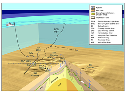
The Gulf of Mexico-Hydrate Research Consortium (GOM-HRC), formed to coordinate efforts of hydrates researchers and to promote effective, efficient communication among them, is in its eleventh year of developing a sea-floor station to monitor hydrates in situ. Consortium management includes facilitating research activities, sensor testing, and deployments; cooperation among participants; and reporting via planning regular consortium meetings and research cruises as well as interacting with sponsoring agencies. Established at and administered by the University of Mississippi’s Center for Marine Resources and Environmental Technology (CMRET), the consortium has, as its primary objective, the design and emplacement of a remote monitoring station on the sea floor in the northern Gulf of Mexico. The Monitoring Station/Sea-Floor Observatory (MS/SFO) is a multi-sensor station that will eventually provide more-or-less continuous monitoring of the near-seabed hydrocarbon system within the hydrate stability zone (HSZ) of the northern Gulf of Mexico.

Observatory components deployed at the foot of the wall of hydrate: Peepers, hydrate collector, mini-osmosampler (left to right)

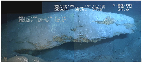
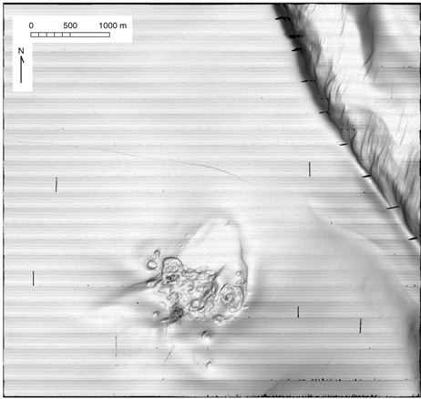
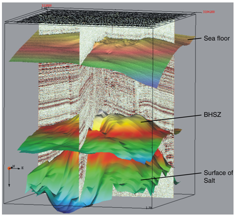
The site of the observatory, Mississippi Canyon 118 (MC 118), is about 100 miles south of Pascagoula, MS, and was chosen by consensus of the consortium and its funding agencies based on favorable hydrate conditions at the site. The site is dominated by a fault-derived canyon in the northwest and a carbonate mound approximately 1km in diameter to the south. The mound is composed of three crater complexes, as seen in the multibeam image below.

Multibeam image of Mississippi Canyon Block 118

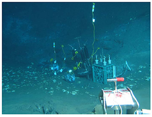
The centerpiece of the SFO will be a series of vertical and horizontal arrays of sensors. One vertical geophysical component is complete and has been tested successfully. It is moored to the sea floor, extends 200 meters into the water column, includes hydrophones to record water-borne acoustic energy (and measure sound speed in the lower water column), thermistors to measure water temperature, tilt meters to sense currents, and compasses to indicate their directions. Another vertical array will consist of hydrophones and 3-component accelerometers to be installed in a borehole. Horizontal water-bottom hydrophone arrays will be laid on the soft sediments of the sea-floor by means of a sea-floor sled designed to lay cable. This sled will also be used as a seismic source of compressional and shear waves. Novel processing techniques for vertical and horizontal array data continue to be developed by consortium participants.

Gas hydrate Sea-Floor Observatory - Mississippi Canyon Block 118


Impact

The SFO is expected to have a profound impact on our understanding of how natural gas hydrate deposits in the GOM undergo change over time and the repercussions of such changes. Quantification of the volume of natural gas released into the water column from hydrate deposits located on or near the sea-floor as seasonal current and temperature changes occur is one very important finding. Data gathered at the SFO will enhance ongoing efforts to model how hydrates form and dissociate, and will play an important role in the development of methodologies for carrying out commercial natural gas recovery and improving our ability to model climate change. In addition, these observed changes are expected to enhance our understanding of how hydrates affect seafloor stability, a factor critical for the placement and operation of subsea equipment, pipelines, and platforms.

Accomplishments (most recent listed first)

2013 Accomplishments:

  • Researchers developed and constructed a sediment probe with acoustic sensors to measure the velocity of shallow sediments.
  • During a cruise to MC118, researchers deployed the UCSB 3-D sonar rotator and used it to record bubble stream activity. A UGA built lander with the Membrane Induction Mass Spectrometer was also deployed and collected a significant amount of data on methane seeps in the area.

2012 Accomplishments:

  • Heat flow data were collected from 15 targeted sites in the vicinity of the MC118 observatory.
  • Researchers used the THROBS model to approximate the base of the hydrate stability zone at MC118 using geochemical data from seafloor arrays and heat flow data.
  • Completed logging and lithostratigraphic analyses of jumbo piston cores collected in January 2011.

2011 Accomplishments:

  • Researchers using ocean bottom seismometers supplied by Woods Hole (USGS) successfully collected 4-C seismic data at the SFO. The data were processed by Woods Hole and sent to the University of Texas BEG for interpretation.
  • During the first six months of 2011, researchers collected and partially analyzed Jumbo piston cores, which contained various forms of hydrates. This success validated the capability to integrate multiple datasets to predict hydrate in the shallow subsurface with greater accuracy than any known single method could provide. A preliminary hydrate 3-gas model is approaching completion.
  • During a January 2011 cruise, Consortium researchers collected five giant pistons cores from selected sites in the vicinity of the MC118 observatory. A section of one of the cores was selected as a good candidate for further examination based on readings from an infrared camera. This section was found to contain hydrates in the form of massive chunks, blades, nodules, and disseminated grains. The selected core was taken from an area which appeared as an anomaly on a previous resistivity survey and is the first confirmation of subsurface gas hydrate at the site. The finding supports prior geophysical interpretations that suggest that gas delivery to the seafloor, and the distribution of subsurface gas hydrate, are primarily controlled by faults. The cores were transported to a Naval Research Laboratory facility for storage and future analysis.
  • The baseline subsurface characterization of the observatory site was completed. An improved image of the subsurface structure beneath the carbonate-hydrate mound at MC 118 is emerging as a result of high- resolution seismic data, geochemical analyses, and data collected from AUV surveys.
  • New constraints on hydrate formation have been established; multibeam technology has been used effectively to measure both volume and frequency of bubble plumes at vents; and a preliminary hydrate 3-gas reservoir simulation model has been completed.

2010 Accomplishments:

  • All horizontal line arrays tested out during pressure testing in Southwestern Research Institute’s large high-pressure testing facility and are ready for deployment at MC118.
  • Test array deployment operations were carried out on an April cruise to MC118 and to Pensacola Bay (suitable sea state).
  • The Data Recovery System—including the integrated data power unit, pop-up buoy, and battery system—for the observatory was deployed successfully at MC118 in April, following adjustments and updates to the communications system.
  • The array pod was successfully deployed 12m from the IDP on a June cruise.
  • Chemical surveying (via mass spec and water samples) conducted in the wake of the Deepwater Horizon spill approximately 10 miles from the observatory showed increased levels of methane at two depths where detectable levels had not been seen in the past. The evidence that chemical changes are occurring in the water column at MC118 is compelling.
  • The GOM Hydrate Research Consortium Meeting was held in Oxford, Mississippi, October 26–27, 2010. Consortium members gave presentations outlining the status of their research projects and discussed the direction of research efforts going forward.
  • The baseline subsurface characterization of the observatory site was completed.

2009 Accomplishments:

  • Geologists and geophysicists from The Universities of South Carolina and Mississippi completed initial analyses of the TGS-NOPEC 3-D data from MC118 and established a baseline geological/geophysical model from which to work. It includes three major faults emanating from a salt dome directly beneath the mound and extending to the seafloor. These appear to control the plumbing system at MC118 but have associated with them with numerous secondary faults that contribute to a series of conduits that afford additional/alternate flow routes for fluids migrating from depth to the seafloor.
  • The ABCMS – Automated Biological Chemical Monitoring System in survey mode detected two methane spikes in the area of the NW crater complex.
  • The Benthic Boundary Layer Array was deployed successfully in March and recovered on a subsequent cruise in June. Data are being analyzed for chemical information as well as for leads to decrease power demands and increase sensor performance.
  • A complete multibeam survey of MC118 was executed in June using the NIUST AUV, Eagle Ray. Early analyses of these data indicate 2 possible new vent sites and pockmarks that have increased in size since the 2005 survey.
  • A June survey with the WHOI mass spectrometer aboard the Eagle Ray also showed methane spikes in areas not previously identified as vent areas. It appears that this area is one of dynamic venting that includes vent “migration”.
  • A DOE-funded Consortium June cruise included a very successful 30+ hour resistivity survey of the mound area by Baylor geophysicists. Early data analyses indicate a need for increased resolution, but show biggest “hits” near the major faults identified by the South Carolina-Mississippi team. It appears that hydrate does, in fact, occupy fractures here and that it may consequently interfere with fluid migration in the hydrate stability zone.
  • Images of bubble streams were successfully retrieved from Coal Oil Point, CA. The multibeam sonar capability has been proven both offshore of CA and in the Arctic and is now being readied for deployment in the deep Gulf.

2008 Accomplishments:

  • During an April coring cruise to MC 118, Consortium researchers recovered 10m cores that included laths and granules of gas hydrates in the fracture porosity of very fine-grained sediments.
  • A second PFA has been deployed west of the northwest crater complex in the area where gas hydrates were recovered in core samples.
  • The Data Recovery System - including the Integrated data power unit, the pop-up buoy and the battery system - for the observatory was deployed successfully at MC118 in June.
  • Brad Battista, doctoral student who developed empirical mode decomposition processing software for Consortium data-processing of high resolution seismic data has completed requirements for his Ph.D. degree from the University of South Carolina.
  • A 3D model of the shallow subsurface (0 - .5 sec), at submeter resolution has been constructed from Consortium high resolution seismic data. A 3D Image derived from surface-source-deep-receiver data shows the sea-floor, the presumed base of the hydrate stability zone and the surface of the salt diapir at MC 118. This is the first 3D model to result from the processing and modeling capabilities developed especially for this project.
  • The Consortium has acquired from TGS-NOPEC Geophysical Company (TGS) a 3D volume of industry-standard seismic data (0 – 3 sec) at 25m resolution and several multi-offset profiles (0 – 5 sec) prior to CDP stack for the purpose of performing AVO (amplitude vs. offset) analysis to elucidate the relationship between compressional propagation and shear propagation.
  • A 3D velocity function suitable for transforming time data to depth data is included in the TGS package
Gas hydrate, center core, is ~3cm X ~1.5cm X ~2mm. Note “spongy” texture of very fine-grained sediments where gas hydrate has dissociated.
A 3D model of the shallow subsurface (0 - .5 sec), at submeter resolution, constructed from Consortium high resolution seismic data

2007 Accomplishments:

  • A second round of processing the 3D reflection seismic data set on the mound in MC 118 has been completed. It differs from the first round of processing in that it uses Empirical Mode Decomposition (Battista et al., 2007) rather than high-cut filtering to attenuate noise in the shallow section. The result appears to be superior to the previous (2006) result and is expected to produce a 3D model with more accurate measurements of P-wave reflection coefficients. This model will be used to initiate inversion of ambient-noise data recorded by the completed observatory.
  • The recovery of the first Pore-Fluid Array (PFA) sample set was accomplished and data analysis is complete. The results indicate that the northern flank of MC 118 is characterized by brine and methane-rich fluids. Since brine inhibits hydrate formation, the presence of brine radically changes the hydrate stability zone, at least locally. Confirming these results, hydrate outcrops have not been observed, visually, at the northern site but are abundant at the southern location. The osmo-sampler package (shown below) was replaced with a new package, and the collection of a second time-series of pore-fluid samples from four discrete depths is currently underway.
  • Successful test of the Station Service Device (SSD). The SSD is a remotely operated vehicle designed especially for use at the Sea-floor Observatory. It will be used for making/breaking underwater connections, placing instruments on the sea-floor, retrieving sensors and sampling devices from the sea-floor, and as a platform for surveying devices such as cameras and mass spectrometers.
  • Successful test conducted of 4-C prototype horizontal line array. The test was unique in that it featured an advanced accelerometer design, demonstrating its effectiveness for incorporation in a 4-Component, hydrophone and accelerometer (for p and s-wave reception respectively) passive seismic array net work.
  • Experiments show that biosurfactants produced by the microbe Bacillus subtilis catalyze hydrate formation, increasing its rate by orders of magnitude and decreasing the length of time prior to its onset.
  • Laboratory experiments also show that biosurfactants promote hydrate nucleation on particles of smectite clay but not on kaolinite clay particles or quartz sand grains. Smectite is a common component of fine-grained sediments in the Gulf of Mexico and would be present in the subsurface, including fracture walls, to provide nucleation sites for hydrates.
  • Derivation of backscatter imagery from reprocessed (3 m resolution) multibeam data.

2006 Accomplishments:

  • A data set of 30,000 normal-incidence reflection seismic traces recorded over the mound in MC 118 was obtained using an 80in3 watergun source at the water surface and a single hydrophone deep-towed (350-400m) vertically below the source. The data set is expected to describe the interior of the mound to a depth of more than 300m below the sea floor with a vertical resolution on the order of a meter. Results are expected to be sufficient to describe the entire hydrate stability zone in the vicinity of the mound. The result appears to be acceptable except for high-frequency noise in the shallow section. The noise is believed to be generated by the ultra-short baseline system used to determine the location of the deep-towed hydrophone. The 30,000-trace data set has been processed using source-signature phase conjugation, spherical-divergence corrections and a high-cut filter to attenuate the noise in the shallow section. The amount of attenuation achieved was less than desired, however, and the filter produced undesired phase shifts. It was decided to redo the processing using the method of Empirical Mode Decomposition described by Battista et al. (2007).
  • A week-long Consortium cruise aboard the Seward Johnson included 10 successful dives of the manned-submersible, Johnson SeaLink at MC 118. During these dives visual and geochemical surveys were conducted, hydrates, venting and chemosynthetic communities documented, sampled and recovered, instruments deployed and recovered, the pore-fluid sampler box exchanged, the data-logger from the thermistor array retrieved, and a camera system, collectors, and samplers deployed for a months-long sea-floor stay. Portions of this cruise were filmed by Discovery Channel subcontractors for the mini-series, Building the Future: Energy.
  • Data recovered from the thermistor array clearly show a diurnal variation in bottom-water temperatures suggesting a tidal nudge of the Loop current on a diurnal frequency at the site.
  • Data Management and Matched Field Processing software for the Sea-floor Monitoring Station have been completed. A prototype database can now be extended and used to house the Observatory data when they become available.
  • A drift camera survey of MC 118 was completed in preparation for deployments.
  • EGL scientists developed software that implements a new theory to create higher-resolution P-SV (P-wave to SV-shear wave conversion) images of near-sea-floor geology from large volumes of 4-component ocean-bottom cable seismic data.
  • Acoustic “wipe-out” zones, evident on chirp sonar records from MC 118 are not indicative of homogenous active methane venting at the sediment water interface, but define three distinct vent types at MC 118.
  • Methane source and microbial controls on methane venting to the overlying water were established.
  • Additional Pore-Fluid Arrays (PFA) – one 8 m and one 0.5 m - for high resolution sampling near a hard ground have been constructed for fall deployment.
  • The Pore Fluid Array (PFA) which had been installed in May 2005 was located, upright and protruding from the sediments by about 2 meters. The sample box was replaced and four-months worth of samples were recovered from the first box.
  • Designs for pressurized pore-water “peepers” were completed and the devices deployed on the sea-floor.
  • 10 box cores collected at MC 118 were analyzed for light hydrocarbon gases, stable isotopes and dissolved ions in an effort to relate geochemistry to geophysics to aid in the interpretation of geophysical data. Results indicate (1) cores are isotopically lighter than the vent gas, suggesting microbial methane production in the surface sediments (2) dissolved methane in the porewaters is a mixture of biogenic and thermogenic sources, with more biogenic methane near the surface (3) three of the cores are depleted in sulfate within 10 cm of the sediment-seawater interface and (4) brine was not present within the surface sediments.
  • Core Samples from two locations in the Mississippi Canyon, MC 118 and MC 798, were analyzed for propensity to form gas hydrates and therefore to constitute possible production level deposits.
  • Indications are that smectite clays promote hydrate formation. Platelets slough off the clay mass and act as nuclei for hydrate formation. Anionic bioproducts may collect in the interlayers of the platelets thereby becoming involved in promoting hydrate formation.
  • Hydrate formation rates and crystal initiation times were measured in the laboratory as a function of depth below sea-floor and as a function of lateral displacement. Effects of six parameters were analyzed with regard to induction times and formation rates and lateral variability documented; depth of the sulfate zone, pore-water salinity, and bioactivity appear to be important in determining ease of hydrate formation in shallow sediments
  • The communications systems for 3-C accelerometer (land seismic) sensors have been modified for a deep-ocean environment. Specialty Devices, Inc. (SDI) is addressing a software and circuitry problem. Upgrades and enhancements to the I/O equipment have been made.

2005 Accomplishments: 
Test of sea-floor probe for sensor deployment and core recovery as well as deployment of pore-fluid sampling and thermistor arrays at MC 118, were successful.

  • Core samples recovered and analyzed for grain size, sedimentation rates, bio- and litho- stratigraphy, mineralogy, hydrate formation/induction times; pore-fluids analyzed for sulfate and methane concentrations.
  • Completion of the sensor, data characterization and data management architecture design for the Station.
  • Acquired AUV data (chirp sonar, multi-beam bathymetry, side-scan sonar) over the entire block, MC 118.
  • Reprocessed, from 5 m to 3 m resolution, AUV multi-beam bathymetric data over the entire block, MC 118.
  • Numerous articles and presentations completed/others begun, including submissions to the Hedberg (AAPG) special publication on gas hydrates, OTC, GCAGS, AAPG’s The Leading Edge, and Mississippi Academy of Sciences.

Pre-2005 Accomplishments:
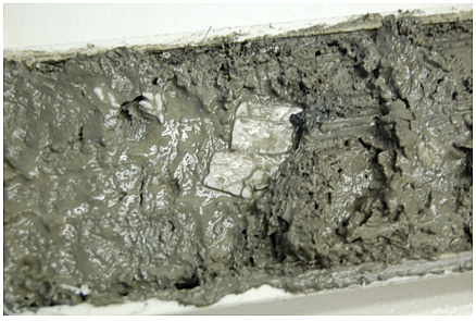
The Consortium identified the site for the Sea-Floor Observatory in Mississippi Canyon 118; designed and constructed the tools necessary to further understand methane hydrates deposits in the GOM (Raman spectrometer, prototype hydrophone vertical line array, and pressure pore-water sampler (PPPS)). The Project documented the first experimental knowledge of microbiological effects on the rate of hydrate formation under Gulf of Mexico sea floor conditions, and measured thermal properties of gas hydrate deposits over a one-year deployment with visual monitoring via time-lapse photography. 

Current Status

(December 2013)
The project ended on July 31, 2013. The final report is available below under "Additional Information".

Project Start
Project End
DOE Contribution

$7,716,830

Performer Contribution

$2,076,202

Project DOE Performer Contribution Total
NT40920 $1,644,007 $477,954 $2,121,961
NT41628 $1,894,815 $553,619 $2,448,434
NT42877 $4,178,008 $1,074,629 $5,252,637
Total $7,716,830 $2,076,202 $9,823,032
Contact Information

NETL – Skip Pratt (skip.pratt@netl.doe.gov or 304-285-4396)
MMRI/CMRET – Carol Lutken (cbl@olemiss.edu or 662-915-7320)

Additional Information

In addition to the information provided here, a full listing of project related publications and presentations as well as a listing of funded students can be found in the Methane Hydrate Program Bibliography [PDF].

Final Project Report [PDF-24.6MB] December, 2013

Gulf of Mexico Hydrates Research Consortium publications: 2000 - 2010 [PDF-165KB]

Final Report for Project NT41268 [PDF-9.63MB]