
Business

Business
As NETL strives to develop technology solutions to the nation’s energy challenges, which includes improving the health, safety and security of all Americans, the Lab is working to locate and quantify methane leaks in the natural gas infrastructure.
A vast pipeline network spanning more than 3 million miles delivers over 24 trillion cubic feet of natural gas to 70 million-plus consumers in the United States each year. This infrastructure includes three categories of pipelines: gathering lines, which transport raw natural gas from wells for processing; transmission lines, which move processed natural gas to distribution centers and storage facilities across the country; and distribution lines, which deliver natural gas to customers.
Transmission and distribution lines are typically well recorded and regulated. However, fewer inspections are required for small-diameter gathering lines, which are also less likely to be mapped or recorded. These gathering lines are of particular interest to NETL researchers, as leaks from gathering lines are not as well characterized.
The first challenge is locating gathering pipelines – both active and inactive – is finding the endpoints of the lines, which usually are wells and processing stations. Processing stations are well marked on maps but individual wells are sometimes not well marked, either on maps or on the ground. A previous NETL study that focused on finding oil and natural gas wells explored the efficacy of aerial surveys by helicopter versus ground surveys by utility terrain vehicle (UTV), either using powerful magnets or methane detection equipment. Aerial magnetic surveys were determined to be the most accurate, economical and time-effective method to locate steel-cased wells in large areas. Helicopters demonstrated advantages over UTVs in their ability to quickly survey a large area and access areas with rough terrain or heavy vegetation.
NETL Technology Portfolio Lead Natalie Pekney, Ph.D., said that finding wells is often easier than locating gathering pipelines, because wells are oriented vertically and generate an obvious magnetic “bull’s-eye.” Meanwhile, gathering systems run horizontally, produce a weaker magnetic signal, and may be made of plastic or other materials that are undetectable using magnets.
Well finding is important because many early wells drilled in the United States were not properly sealed when they were abandoned, creating pathways for liquids and gases to rise to the surface or flow underground. Poorly sealed wells can contaminate sources of drinking water, release harmful gases and threaten the success of subsurface energy-related activities – including hydraulic fracturing, enhanced oil recovery and carbon storage. Leaking pipelines may also pose some of these threats, so as NETL has refined effective well-finding techniques, research has transitioned to locating gathering lines and characterizing any leakage from those lines.
To extend the impact of site studies and surveys like NETL’s helicopter work, another NETL team uses geospatial data analytics and modeling to provide useful information about the nation’s natural gas pipeline network. For instance, data analyses have highlighted patterns in regions of the country prone to incidents that can lead to severe injury or explosions from excavation damage – in regions experiencing rapid development – and corrosion – in offshore environments, such as the Gulf of Mexico. These analytics can utilize public records pertaining to transmission and distribution lines to help determine where gathering lines are likely to be located or cause leakage issues. These studies also help researchers and pipeline operators focus maintenance and advanced mitigation efforts.
Methane is the primary hydrocarbon contained within natural gas. While it has explosive limits, some methane is naturally present within the atmosphere – about 1.9 parts per million. Quantifying methane leaks from gathering pipelines helps not only to ensure public safety, but also to more accurately assess greenhouse gas emissions. The information gleaned from NETL’s work will be shared with the U.S. Environmental Protection Agency to update Greenhouse Gas Inventory emission estimates for gathering systems, which are currently based on data from distribution pipelines. “In order to more accurately estimate leaks from gathering systems, we should be collecting measurements from gathering systems, not distribution lines,” Pekney said.
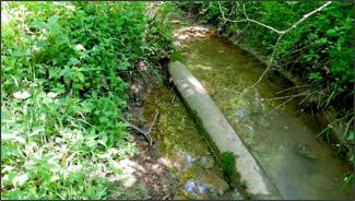
NETL conducted a preliminary two-day ground survey at Moshannon State Forest near Dubois, Pennsylvania, where 13 miles of gathering pipelines were surveyed using a UTV equipped with methane detection technology. The survey found maximum methane concentrations around 5 parts per million – a level considered low, Pekney said. Researchers are now working to determine the possible factors that impact methane leak rates for gathering pipelines, including age, region of the country and pipeline materials. Several environmental variables – such as wind speed and direction, humidity, barometric pressure, weather patterns and soil conditions – are also measured or recorded, as they can impact the integrity of the pipeline and influence the dispersion of methane into the atmosphere from a leak.
Researchers are simultaneously working to improve methane detection methods, as sensor altitude, sample rates and more can affect leak detection. Aerial surveys require highly sensitive detectors, because low-level leaks are often undetectable at higher altitudes. In addition, follow-up at ground level is typically necessary. However, solely ground-based surveys take more time and are limited based on accessibility. For both methods, making multiple passes through an area boosts accuracy but also raises cost.
Researchers are now exploring the use of unmanned aerial vehicles (UAVs), commonly referred to as drones, that can monitor, measure, detect and document environmental conditions in remote, dangerous and otherwise inaccessible areas using new technology. UAVs offer the potential to reduce costs, improve data quality, increase safety and provide greater convenience – both for locating legacy gathering pipelines and detecting methane leaks.
Vital information gathered through NETL studies like these contributes to the Lab’s efforts to develop robust technological resources that meet energy-related research needs. For instance, the first global oil and gas infrastructure inventory, released in April via NETL’s Energy Data eXchange (EDX), identifies more than 4.8 million individual features – including wells and pipelines – from more than 380 data sets in 194 countries. This database offers the unique ability to enhance record-keeping, evaluate lessons learned, distinguish trends and identify research and technology gaps. These tools, along with data on locating gathering pipelines and quantifying methane leaks, enhances NETL’s reputation as a renowned fossil-energy science and engineering resource working to ensure public health, safety and security through responsible stewardship of the environment.
Contact:

