
Business

Business
The goal is to help maintain the nation's natural gas transmission infrastructure through the timely and effective detection of natural gas leaks through evaluation of geobotanical stress signatures.
Lawrence Livermore National Laboratory (LLNL) – project management and research products
NASA – Ames – Development of UAV platform used to carry hyperspectral payload
HyVista Corporation– Development and operation of the HyMap hyperspectral sensor
Location:
Livermore, CA 94511
The remote sensing techniques being developed employ advanced spectrometer systems that produce visible and near infrared reflected light images with spatial resolution of 1 to 3 meters in 128 wavelength bands. This allows for the discrimination of individual species of plants as well as geological and man-made objects, and permits the detection of biological impacts of methane leaks or seepages in large complicated areas. The techniques employed do not require before-and-after imagery because they use the spatial patterns of plant species and health variations present in a single image to distinguish leaks. Also, these techniques should allow discrimination between the effects of small leaks and the damage caused by human incursion or natural factors such as storm run off, landslides and earthquakes. Because plants in an area can accumulate doses of leaked materials, species spatial patterns can record time-integrated effects of leaked methane. This can be important in finding leaks that would otherwise be hard to detect by direct observation of methane concentrations in the air.
This project is developing remote sensing methods of detecting, discriminating, and mapping the effects of natural gas leaks from underground pipelines. The current focus is on the effects that the increased methane soil concentrations, created by the leaks, will have on plants. These effects will be associated with extreme soil CH4 concentrations, plant sickness, and even death. Similar circumstances have been observed and studied in the effects of excessive CO2 soil concentrations at Mammoth Mountain near Mammoth Lakes California, USA. At the Mammoth Mountain site, the large CO2 soil concentrations are due to the volcanic rumblings of the magma still active below Mammoth Mountain. At more subtle levels this research has been able to map, using hyperspectral air borne imagery, the tree plant stress over all of the Mammoth Mountain. These plant stress maps match, and greatly extend into surrounding regions, the on-ground CO2 emission mapping done by the USGS in Menlo Park, California.
In addition, vegetation health mapping along with altered mineralization mapping at Mammoth Mountain does reveal subtle hidden faults. These hidden faults are pathways for potential CO2 leaks, at least near the surface, over the entire region. The methods being developed use airborne hyperspectral and multi-spectral high-resolution imagery and very high resolution (0.6 meter) satellite imagery. The team has identified and worked with commercial providers of both airborne hyperspectral imagery acquisitions and high resolution satellite imagery acquisitions. Both offer competent image data post processing, so that eventually, the ongoing surveillance of pipeline corridors can be contracted for commercially. Current work under this project is focused on detecting and quantifying natural gas pipeline leaks using hyperspectral imagery from airborne or satellite based platforms through evaluation of plant stress.
The use of geobotanical plant stress signatures from hyperspectral imagery potential offers a unique means of detecting and quantifying the existence of natural gas leaks from the U.S. pipeline infrastructure. The method holds the potential to cover large expanses of pipeline with minimal man effort thus reducing the potential likelihood that a leak would go undetected. By increasing the effectiveness and efficiency of leak detection, the amount of gas leaked from a site can be reduced resulting in decreased environmental impact from fugitive emissions of gas, increased safety and reliability of gas delivery and increase in overall available gas; as less product is lost from the lines.
Results:
Created an advanced Geographic Information System (GIS) that will be able provide dynamic integration of airborne imagery, satellite imagery, and other GIS information to monitor pipelines for geobotanical leak signatures.
Used the software to integrate hyperspectral imagery, high resolution satellite imagery, and digital elevation models of the area around a known gas leak to determine if evidence of the leak could be resolved.
Helped develop hyperspectral imagery payload for use on an unmanned aerial vehicle developed by NASA-Ames.
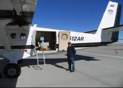
Participated in DOE-NETL sponsored natural gas pipeline leak detection demonstration in Casper, Wyoming on September 13-17, 2004. Using both the UAV hyperspectral payload (~1000 ft), and Hyvista hyperspectral platform (~5000 ft) to survey for plant stress.
The method chosen for testing these techniques was to image the area surrounding known gas pipeline leaks. After receiving notice and location information for a newly discovered leak from research collaborator Pacific Gas and Electric (PG&E), researchers determined the area above the buried pipeline to be scanned, including some surrounding areas thought to be outside the influence of any methane that might percolate to within root depth of the surface. Flight lines were designed for the airborne acquisition program and researchers used a geographic positioning system (GPS) and digital cameras to visually record the soils, plants, minerals, waters, and manmade objects in the area while the airborne imagery was acquired. After the airborne imagery set for all flight lines was received (including raw data, data corrected to reflectance including atmospheric absorptions, and georectification control files), the data was analyzed using commercial computer software (ENVI) by a team of researchers at University of California, Santa Cruz (UCSC), Lawrence Livermore National Laboratory (LLNL), and one of the acquisition contractors.
Researchers used several different routines available within the ENVI program suite to produce “maps” of plant species types, plant health within species types, soil types, soil conditions, water bodies, water contents such as algae or sediments, mineralogy of exposed formations, and manmade objects. These maps were then studied for relative plant health patterns, altered mineral distributions, and other categories. The researchers then returned to the field to verify and further understand the mappings, fine-tune the results, and produce more accurate maps. Since the maps are georectified and the pixel size is 3 meters, individual objects can all be located using the maps and a handheld GPS.
These detailed maps show areas of existing anomalous conditions such as plant kills and linear species modifications caused by subtle hidden faults, modifications of the terrain due to pipeline work or encroachment. They are also the “baseline” that can be used to chart any future changes by re-imaging the area routinely to monitor and document any effects caused by significant methane leakage.
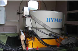
The sensors used for image acquisition are hyperspectral scanners, one of which provides 126 bands across the reflective solar wavelength region of 0.45 – 2.5 nm with contiguous spectral coverage (except in the atmospheric water vapor bands) and bandwidths between 15 – 20 nm. This sensor operates on a 3-axis gyro-stabilized platform to minimize image distortion due to aircraft motion and provides a signal to noise ratio >500:1. Geo-location and image geo-coding is achieved with an-on board Differential GPS (DGPS) and an integrated IMU (inertial monitoring unit).
During a DOE – NETL sponsored natural gas leak detection demonstration at the National Petroleum Reserve 3 (NPR3) site of the Rocky Mountain Oilfield Testing Center (RMOTC) outside of Casper, Wyoming, the project utilized hyperspectral imaging of vegetation to sense plant stress related to the presence of natural gas on a simulated pipeline using actual natural gas releases. The spectral signature of sunlight reflected from vegetation was used to determine vegetation health. Two different platforms were used for imaging the virtual pipeline path: a Twin Otter aircraft flying at an altitude of about 5,000 feet above ground level that imaged the entire site in strips, and an unmanned autonomous vehicle (UAV) flying at an altitude of approximately 1,000 feet above ground level that imaged an area surrounding the virtual pipeline.
The manned hyperspectral imaging took place on two days. Wednesday, September 9 and Wednesday, September 15. The underground leaks were started on August 30. This was done to allow time for the methane from the leaks to saturate the soils and produce plant stress by excluding oxygen from the plant root systems. On both days, the entire NPR3-RMOTC site was successfully imaged.
At that time of year, the vegetation at NPR3-RMOTC was largely in hibernation. The exception was in the gullies where there was some moisture. Therefore, the survey looked for unusually stressed plant “patches” in the gullies as possible leak points. Several spots were found in the hyperspectral imagery that had the spectral signature typical of sick vegetation that were several pixels in diameter in locations in the gullies or ravines along the virtual pipeline route. Due to the limited vegetation along the test route the successful detection of natural gas leaks through imaging of plant stress was limited in success. The technique did demonstrate an ability to show plant stress in areas near leak sites but was less successful in determining general leak severity based on those results. In areas with much denser vegetation coverage and less dormant plant life the method still shows promise.
Overall results from the DOE-NETL sponsored natural gas leak detection demonstration can be found in the demonstration final report [PDF-7370KB] .
All work under this project has been completed.
$966,900
$0
NETL – Richard Baker (richard.baker@netl.doe.gov or 304-285-4714)
LLNL – Dr. William L. Pickles (pickles1@llnl.gov or 925-422-7812)
DOE Leak Detection Technology Demonstration Final Report [PDF-838-KB]
DOE Fossil Energy Techline: National Labs to Strengthen Natural Gas Pipelines' Integrity, Reliability
Status Assessment [PDF-26KB]

