Business

Business
The principal goal was to develop algorithms for estimating reservoir properties (permeability and porosity fields and boundaries between geologic facies) by automatic history-matching of production data.
Program
This project was selected in response to DOE's Oil Exploration and Production solicitation DE-PS26-01NT41048 (focus area: Critical Upstream Advanced Diagnostics and Imaging Technology). The goal of the solicitation is to continue critical cross-cutting, interdisciplinary research to develop innovative technologies for imaging and quantifying reservoir rock and fluid properties for improved oil recovery.
University of Tulsa - Tulsa, OK
University of Oklahoma - Norman, OK
Despite long-standing interest in the oil and gas industry, automatic history-matching seldom has been used in practice due to a lack of computational efficiency. Manual history-matching has been the norm. Consequently, reservoir engineers often have made changes to reservoir simulation models that resulted in a history-matched reservoir model inconsistent with static data and geologic information and interpretation. As a result, the model obtained by history-matching often gave unreliable predictions of future reservoir performance. When implemented in commercial software, the algorithms and technology developed in this research project will provide a platform for data integration with the history-matching process in order to obtain a history-matched reservoir model that is consistent with all data and information. This will result in better predictions of future production and quantification of uncertainty in predicted reservoir performance and thus lead to improvements in reservoir management.
Project Results
Researchers developed an adjoint method for computing the sensitivity of production data and time-lapse seismic data and coupled it with a limited-memory Broyden-Fletcher-Goldfarb-Shanno optimization algorithm. The combination of these two procedures resulted in an efficient, automatic history-matching algorithm for constructing reservoir models consistent with both static and dynamic data.
Benefits
The technology developed makes large-scale automatic history-matching feasible and provides the opportunity to obtain a more accurate reservoir map of reservoir properties by tracking fluid movement and quantifying fluid distributions. Knowledge of the distribution of reservoir properties and fluids is critical for developing a reservoir management plan to optimize oil recovery. Five Ph.D. students completed the research requirements for their degrees by working on the project. All five are now employed with oil industry firms, where they will be able to employ novel technology to improve reservoir management.
Project Summary
The project:
Geologic models containing millions of cells and reservoir simulation models containing over several tens of thousands of gridblocks are common in today's environment. Yet prior to this project, no technology existed for adjusting all grid block permeabilites and porosities to obtain a model history-matched to production and seismic data while honoring static data. This project developed robust automatic history-matching algorithms for such large-scale problems and demonstrated their applicability on field and pseudo-field examples containing tens of thousands of grid blocks. The algorithms can be used to history-match both production and seismic data. The other milestones pertain to specific problems that needed to be overcome in order to attain automatic history-matching for large-scale problems.
To integrate seismic data into reservoir description, researchers implemented rock physics models in code to compute acoustic impedance from pressure and saturation distributions and rock and fluid properties. Then the adjoint method was implemented to compute the sensitivities of time-lapse seismic data (change in acoustic impedance) to rock-property fields so that reservoir models can be adjusted by history-matching time-lapse seismic data. The project demonstrated that history-matching both production and time-lapse seismic data resulted in a more accurate reservoir description than can be obtained by history-matching only production data. Moreover, a more accurate description of the distribution of reservoir fluids is obtained, which provides a means to monitor water and gas injection projects.
One of two key steps for developing computationally feasible automatic history-matching algorithms was the development and implementation of an adjoint method for computing the sensitivity of production and time-lapse seismic data to rock property fields specifically for multiphase flow problems. This method enables the gradient of the objective function minimized to secure a history-matched model to be obtained in less work than is required for one forward reservoir simulation run.
Lab relative-permeability curves provide an initial estimate of relative permeability curves but may not be applicable for reservoir simulation models because of the large grid blocks. Using power law models, researchers demonstrated that it is possible to estimate relative permeability curves as well as the gridblock porosities and absolute permeabilities by automatic history-matching
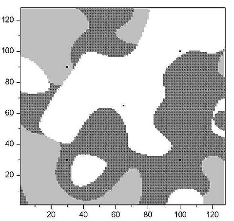
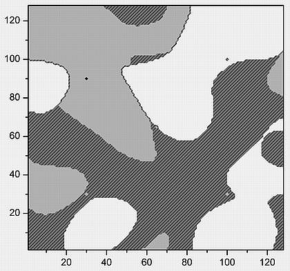
The variation of permeability and porosity within a specific facies is often much less than the variability between facies. Thus it is important to estimate facies boundaries during the history-matching process. The project developed a novel pluri-Gaussian model that allows one to model the distribution of facies and to implement a procedure for generating sensitivity coefficients so that the location of boundaries between facies can be estimated by the automatic history-matching of production data.
(July 2005)
Since project completion, researchers have developed improved methods for estimating relative permeability curves by matching production data and improved algorithms for history-matching time-lapse seismic data.
Publications
The final DOE report was submitted December 2004. The following is a partial list of conference presentations. Contact the project manager for a complete list of publications.
Reynolds, A.C., "Optimization algorithms for automatic history-matching of production data," European Conference on Mathematics of Oil Recovery, Freiberg, Germany, 2002.
Zhang, F., "Automatic history-matching in a Bayesian framework," SPE Annual Technology Conference and Exhibition, Denver, 2003.
Reynolds, A.C., "An Automatic History-Matching Example," EAGE 65th Conference and Exhibition, Stavanger, Norway, 2003.
Gao, G., "An improved implementation of the LBFGS algorithm for automatic history-matching," SPE Annual Technical Conference and Exhibition, Houston, 2004.
Gao, G., "The Tengiz field history-matching problem revisited," SPE Annual Technical Conference and Exhibition, Houston, 2004.
Liu, N., and Oliver, D.S., "Automatic history-matching of geologic facies," SPE Journal, 8(2), 188-195, 2004.
$577,315
$296,500 (34% of total)
NETL-Daniel Ferguson (Daniel.ferguson@netl.doe.gov or 918-699-2047)
University of Tulsa-Al Reynolds (reynolds@utulsa.edu or 918-631-3043)