Business

Business
The strategic objective of the project was to develop a new procedure to create high-resolution 3-D reservoir characterizations (less than five feet vertical resolution) that are significantly less uncertain and more accurate than previous Geostatistical approaches, are linked to geologic principles and rock physics, and that are presented directly in terms of the engineering parameters needed for reservoir simulation (i.e. porosity, fluid saturations, permeability). An additional goal was to validate and demonstrate the practical application of the high-resolution 3-D reservoir characterization methods in a producing oil field.
Program
This research was selected from a broad-based solicitation DE-PS26-01NT41048 issued in December 2000 that had three focus areas: 1) Access to oil not recoverable by conventional methods by developing improved methods of gas, chemical and microbial flooding for light oil recovery, 2) Address the need for improvements in the way geophysical data are acquired, processed and interpreted, and 3) Address the need for reducing compliance costs and improving environmental performance by providing lower-cost compliance technologies. The overall goal of the solicitation is to develop improved technologies that can extend the life of marginal fields and improve access to the billions of barrels of unproduced oil remaining in the Nation's reservoirs.
Advanced Resources International
Houston, TX
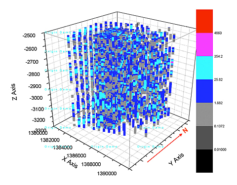
Effective oil field management requires 3-D high resolution reservoir characterization to identify reservoir heterogeneity for enhanced recovery efforts, monitoring and CO2 sequestration. Surface seismic is the most cost-efficient method to obtain inter-well volumetric reservoir information to base decisions on, but the vertical resolution is insufficient (>50 ft) for optimal water or CO2 injection management.
The need for high-resolution 3-D data for flow modeling and forecasting performance is increasingly important as the cost of drilling increases. Operators need to know precisely where to drill new and infill wells and where to complete wellbores to penetrate the desired oil producing intervals. ChevronTexaco provided a wide sweep of different data acquired over McElroy field in recent years for the research project and will verify the results of the study by comparing simulation predictions with production data.
Project Results
The project used existing data from McElroy field in west Texas to test data acquisition capabilities to improve vertical resolution and reduce uncertainty in reservoir characterization. The project evaluated a number of methods of data acquisition and cross checked their performance, ranking high-resolution and cost-effective technologies for use by independent operators. Advanced pattern recognition technologies based on artificial neural networks and clustering techniques provide the best, fast, low-cost analysis.
Benefits
Reduced time and lower cost technologies result in "better, faster, cheaper" reservoir characterization and prediction methods for independents. Clustering modeling techniques based on seismic and log derived predictions of porosity and permeability are accurate at a resolution of 10 to 35 ft, and are significantly lower in cost than coring and traditional core interpretations which are very labor intensive.
Project Summary
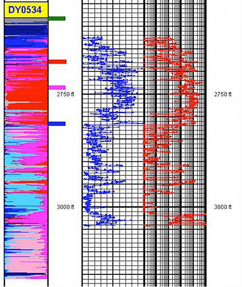
Seismic techniques developed in recent years leave a "resolution gap" between the surface seismic data with resolution of fifty to hundreds of feet, and sonic and ultrasonic logs with resolution in inches. The detail provided by sonic and ultrasonic logs is too costly for many operators or inapplicable under certain field circumstances. Borehole seismic techniques, including cross well, VSP and reverse VSP offer the best intermediate resolution data to fill the resolution gap.
Advanced pattern recognition technologies relying on artificial neural networks and clustering were used to integrate multi-scale data from cores, logs, seismic, crosswell and VSP data. The idea was to generate high-frequency reservoir descriptions at each 3-D seismic trace location. The objective is to demonstrate and validate the integrated virtual intelligence procedure at a single field.
Pattern Recognition differs from inversion technology
Main data processing elements
Acoustic impedence was determined to be a good predictor of porosity using the clustering analysis technique. An inverse trend between well log acoustic impedence and porosity exists because porosity increase as bulk density decreased and as velocity decreases. Permeability can be related to porosity for predictive purposes.
Conclusions
(September 2004)
The project is complete. Validation of the research by Chevron/Texaco will be included in the report. Chevron/Texacos validation will compare the cluster model porosity and permeability predictions against existing knowledge of reservoir properties based on whole cores and production data.
$749,828
$271,284 (26.5% of total)
NETL - Daniel Ferguson (daniel.ferguson@netl.doe.gov or 918-699-2047)
ARI - Scott Reeves (sreeves@adv-res-hou.com or 713-780-0815)