Business

Business
The goals of this project are to:
University of Alaska (UAF), Fairbanks, AK
Alaska Division of Geological & Geophysical Surveys (DGGS), Fairbanks, AK
The Bristol Bay program is a 3-year geologic research effort funded by NETL’s Alaska Energy Technology Development Laboratory, Bristol Bay Native Corporation (BBNC), DGGS, and DOG. DGGS, as lead agency, is collecting and interpreting new data using modern analyses and methodology and is producing the first public, electronically available, quantitative hydrocarbon reservoir data set. Work with these data is codifying the fundamental reservoir characteristics of potential basin targets, placing the reservoir data in a sequence stratigraphic framework, and summarizing the hydrocarbon potential of this frontier basin.
Results
The project performers continue to promote energy development in the Bristol Bay region by creating new petroleum system-related data. These data include seal capacity, source rock types, thermal maturation, petrophysics, reservoir characterization, baseline outcrop geologic mapping, and other critical hydrocarbon exploration information. Mechanisms for conveying these data to industry and the public include a presentation of a Bristol Bay oral session and poster session at the annual meeting of the American Association of Petroleum Geologists (AAPG) in Long Beach, CA, on April 2–4, 2007. These were published as abstracts by AAPG and given to each of the 5,500 registrants on a CD and in the paper abstract volume. Both abstracts were distributed by Bristol Bay Native Corporation (the project’s industry sponsor) at the NAPE (formerly the North American Prospect Expo) meeting in Houston, TX, on February 7–8, 2007.
Progress continues on track and includes the December DGGS Raw Data File publication “2006 Bristol Bay, Alaska Peninsula field summary and outcrop sample results from porosity and permeability and mercury injection capillary pressure analyses”. This report includes discussion of megafossils, palynology, and high-pressure mercury injection capillary pressure analysis and features up-to-date data with sample location maps, data figures, and data tables.
The next peer-reviewed DGGS publications will be a data release in October, after the last field season. The final peer-reviewed publication is scheduled for December 2007. All released reports are available on the DGGS website at www.dggs.dnr.state.ak.us/pubs [external site]. Related data, maps, and reports released by Alaska’s Department of Natural Resources’ (DNR) Division of Oil & Gas (DOG) are also available, at dog.dnr.alaska.gov [external site].
Benefits
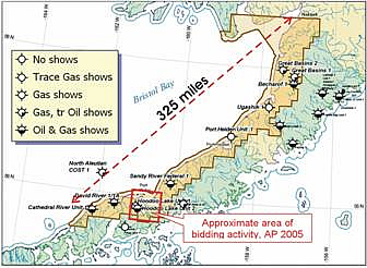
Work on the Bristol Bay-Alaska Peninsula petroleum system has greatly enhanced the hydrocarbon-related knowledge that directly bears on energy exploration and assessment. Researchers have published six peer-reviewed reports and some 12 abstracts at national and international meetings. These efforts benefit the local Bristol Bay population because the possibility of finding extractable oil and gas resources grows more likely as the geologic understanding increases. A major oil company and a small independent producer leased blocks at the 2005 Alaska Peninsula onshore areawide lease sale of state acreage for bids totaling $1.3 million. The acreage acquired was in the Port Moller area.
Summary
All data will be published in peer-reviewed DGGS reports, accessible on the DGGS website. It is anticipated that project data and reports will catalyze future exploration interest and the development of resource-target models, particularly by small independent companies. Participating geologists are from DGGS, DOG, UAF, Purdue University, Bristol Environmental & Engineering Services Corporation, and U.S. Geological Survey. All rock samples will be archived and indexed at the DGGS Geologic Materials Center in Eagle River, AK, upon project completion.
Reservoir characteristics will be quantified using petrophysics (~300 porosity and permeability samples), detailed petrographic analysis, facies analysis, and stratigraphic section measurements. Data will be entered into a GIS-compatible Access database. Publicly available subsurface seismic and well-log data will be integrated to develop a subsurface cross section that interprets the extent of principal target reservoirs. Regional magnetics and gravity will be incorporated into the basin analysis.
Subsurface and surface samples for apatite fission tract analysis will provide data for reconstructing burial and uplift history. Organic geochemistry of source rock material from wells and outcrop will provide details of thermal maturity, source rock affinity, and whether it is gas- or oil-prone. Defining stratigraphy through facies analysis, depositional environment interpretation, and net sand assessment will be based on measured outcrop exposures. Tying the seismic profiles to the several available wells further defines basin architecture and delineates potential hydrocarbon play types.
Among the researchers’ conclusions are the following observations:
(April 2007)
All proposed tasks and milestones are on track and on schedule. The final report will be released December 2007 as a DGGS peer-reviewed publication, which will be web-accessible.
Work items are shown followed by percent complete:
Funding
This project was awarded under DOE solicitation number DE-FC26-01NT41248. In calendar year 2007, Alaska’s DOG allocated an additional $30,000 to “Bristol Bay Energy Development.” These DNR funds are supplemental to funding identified in the original AETDL-Alaska DNR matching-funds agreement. The goals of both agencies are identical. The State of Alaska DNR Capital Improvement Project funding ($30,000) is a function of interest by industry, public, academic, and political leaders.
$693,161
$754,700 (DGGS and DOG 86 percent; Bristol Bay Native Corporation 14 percent)
NETL - James Hemsath (james.hemsath@netl.doe.gov or 907-452-2672)
DGGS – Rocky R. Reifenstuhl (rocky@dnr.state.ak.us or 907-451-5026
Publications
Gillis, R.J., Reifenstuhl, R.R., Decker, P.L., Strauch, A.L., Hemold, K.P., “Bristol Bay petroleum system field studies: Seal capacity, reservoir and coal quality, and structural architecture of the Staniukovich Peninsula, Port Moller area, Alaska Peninsula,” in preparation.
Decker, P.L., Finzel, E.S., Ridgway, K.D., Reifenstuhl, R.R., and Blodgett, R.B., 2005, “Preliminary summary of the 2005 field season: Port Moller, Herendeen Bay, and Dillingham areas, Bristol Bay Basin, Alaska Peninsula,” 55 pp., 2 sheets, PIR 2005-7 [external site].
Finzel, E.S., Reifenstuhl, R.R., Decker, P.L., and Ridgway, K.D., 2005, “Sedimentology, stratigraphy, and hydrocarbon reservoir-source rock potential, using surface and subsurface data, of Tertiary and Mesozoic strata, Bristol Bay Basin and Alaska Peninsula,” 69 pp., PIR 2005-4 [external site].
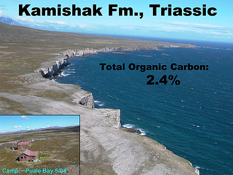
Reifenstuhl, R.R., Shafer, D.C., Ryherd, T.J., Brizzolara, D.W., and Blodgett, R.B., “Summary of May 25–June 4, 2004, field notes and samples, Puale Bay and Wide Bay areas, Alaska Peninsula, 16 pp., RDF 2004-3 [external site].
Reifenstuhl, R.R., Bailey, R.D., and Finzel, E.S., 2005, “Bristol Bay and Alaska Peninsula 2004: Fieldwork and sample analyses compilation report, 20 pp., PIR 2005-1 [external site].
Strauch, A.L., Gillis, R.J., Reifenstuhl, R.R., and Decker, P.L., 2006, “2006 Bristol Bay, Alaska Peninsula field summary and outcrop sample results from porosity & permeability and mercury injection capillary pressure analyses,” 65 pp., RDF 2006-1 [external site].