Back to Top
Skip to main content
NETL Logo
Major Oil Plays in Utah and Vicinity/PUMP 2
Project Number
DE-FC26-02NT15133
Goal

The primary goal of this study is to increase recovery of oil reserves from existing reservoirs and from new discoveries by providing play portfolios for the major oil-producing provinces (Paradox Basin, Uinta Basin, and thrust belt) in Utah and adjacent areas in Colorado and Wyoming. The overall objectives of this study are to: 1) increase recoverable oil from existing reservoirs, 2) add new discoveries, 3) prevent premature abandonment of numerous small fields, 4) increase deliverability through identifying the latest drilling, completion, and secondary/tertiary recovery techniques, and 5) reduce development costs and risk.

Performer(s)

Utah Geological Survey (UGS), Salt Lake City, UT

Background

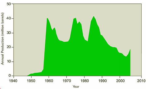
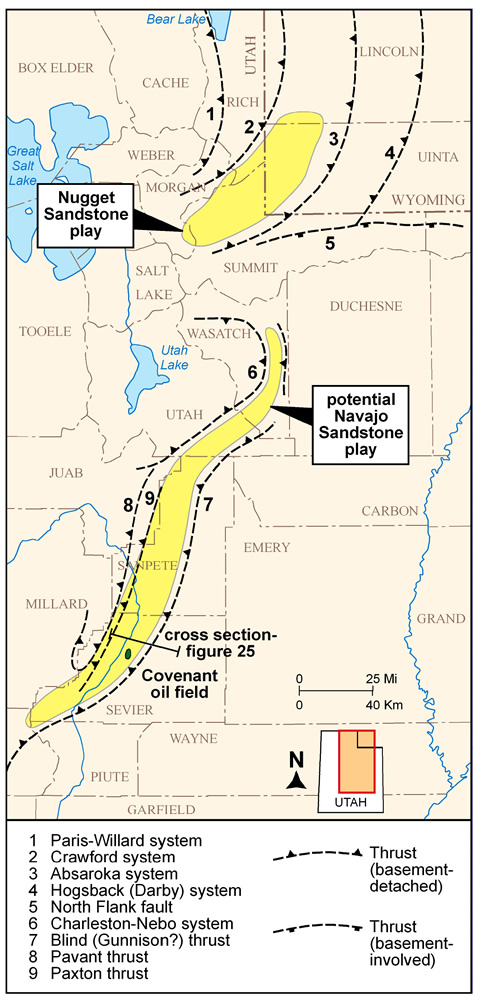
Utah’s drilling history has fluctuated greatly due to discoveries, oil price trends, and changing exploration targets. The state’s oilfields have produced over 1.2 billion barrels of oil. The 13.7 million barrels of production in 2002 was the lowest level in over 40 years and continued the steady decline that began in the mid-1980s. However, in late 2005, production increased following the discovery of Covenant field in the central Utah Navajo Sandstone thrust belt play and reversed the decline that had begun in the mid-1980s. With higher oil prices now prevailing, operators are likely to use improved reservoir characterization and the latest drilling, completion, and secondary and tertiary recovery techniques to boost future production rates and ultimate recovery from known fields. Sustained high petroleum prices also are likely to provide the economic climate needed to entice more high-risk exploration investments, resulting in new discoveries. Utah still contains large areas that are virtually unexplored. New exploratory targets may be identified from 3-D seismic surveys. Development of potential prospects is within the economic and technical capabilities of both major and independent operators. Small, independent operators that drill many of the oil wells in Utah typically do not have the staff or financial resources to compile and assess data on producing trends and state-of-the-art drilling technologies that the UGS project will provide.

Results
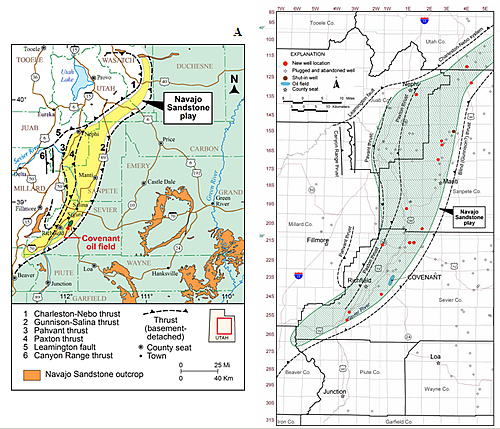
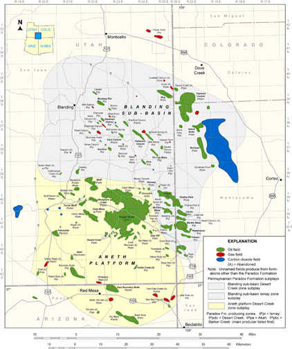
The UGS project has produced a very popular new oil and gas field and pipeline map (hard copy and digital formats), which was updated in 2005. Ten oil plays and 13 subplays have been described, including the new central Utah thrust belt Jurassic Navajo Sandstone subplay—the location of a major new oil discovery, Covenant field, by Wolverine Oil & Gas Company.

Benefits
Project benefits include:

  • Improved reservoir characterization to prevent premature abandonment of numerous small fields in the Paradox and Uinta Basins.
  • Identification of the type of untapped compartments created by reservoir heterogeneity to increase reserves.
  • Identification of the latest drilling, completion, and secondary/tertiary recovery techniques to increase deliverability.
  • Identification of reservoir trends for field extension drilling and stimulating exploration in undeveloped parts of producing fairways.
  • Identification of technology used in other identified basins or trends with similar types of reservoirs that might improve production in Utah.
  • Identification of optimal well spacing/location to reduce the number of wells needed to successfully drain a reservoir to reduce development costs and risk.
  • Technology transfer to encourage new development and exploration efforts and increase royalty income to the Federal, State, local, and tribal governments and to fee owners.

The Utah play portfolios produced by this project will provide an easy-to-use geologic, engineering, and geographic reference to help petroleum companies plan exploration, land-acquisition strategies, and field development. These portfolios may also help pipeline companies plan future facilities and pipelines. Other users of the portfolios will include petroleum engineers, petroleum land specialists, landowners, bankers and investors, economists, utility companies, manufacturers, county planners, and numerous government agencies.

Summary
The project:

  • Described best completion and production practices for 1) Nugget Sandstone and Twin Creek Limestone thrust belt plays; 2) conventional southern Uinta Basin, conventional northern Uinta Basin, and the deep Uinta Basin overpressured continuous plays in Utah; and 3) the Mississippian Leadville Limestone play in the Paradox Basin.
  • Described the 1) conventional southern Uinta Basin (including six subplays), conventional northern Uinta Basin (including two subplays) and the deep Uinta Basin overpressured continuous plays in Utah, 2) Nugget Sandstone and Twin Creek Limestone thrust belt plays (including five subplays) in Utah and Wyoming; and 3) the Mississippian Leadville Limestone and Pennsylvanian Paradox formation plays (including four subplays) in Utah, Colorado, and Arizona.
  • Described reservoir outcrop analogs for all major oil plays in Utah and vicinity.
  • Produced land classification maps and land ownership acreage summaries for the major oil-producing provinces as part of the analysis of land-use constraints documenting the major land and mineral ownership types in each oil-producing province; identified the Federal, State, county, and private and non-profit organizations involved in the environmental analysis, leasing, and development of oil and gas resources; and provided an overview and listing of pertinent data, documents, and research tools that might be helpful in understanding the oil and gas industry, primarily in Utah but also in Arizona, Colorado, and Wyoming.
  • Conducted technology transfer activities that included displaying project goals and results at ten meetings, making 22 presentations at technical conferences or public meetings, conducting a core workshop and a field trip stop on the Jurassic Navajo Sandstone reservoir from Covenant field in the central Utah thrust belt play, and updating the UGS project website on a quarterly basis (see website at http://geology.utah.gov/emp/pump/index.htm [external site], containing all Quarterly Technical Progress Reports and poster presentations. Also, 19 abstracts and papers have been published (excluding Quarterly Technical Progress Reports), including a detailed paper on the geology of Covenant field in the Utah Geological Association’s 2007 guidebook titled “Central Utah – Diverse Geology of a Dynamic Landscape.”

The central Utah thrust belt Jurassic Navajo Sandstone play map produced by the UGS project has continued to featured in numerous published articles. In addition to presentations, UGS geologists continue to answer numerous inquiries about the play from government officials, geologists, the news media, landowners, and the general public.

Current Status

(January 2009)
The project was scheduled for completion on December 31, 2007. There have been four no-cost extensions granted—the last primarily a result expanded effort to describe in detail the land use ownership and regulations, and continued technology transfer activities associated with the Covenant discovery and the new central Utah thrust belt Jurassic Navajo Sandstone play. The UGS will produce an interactive, menu-driven digital product of the play portfolios, maps, core photographs of type core, oil analyses, etc., on a compact disc. The final report is available below under "Additional Information".

Funding
This project was selected in response to DOE’s PUMP (Preferred Upstream Management Practices) 2 solicitation DEPS26-01BC15300, June 2001.

Project Start
Project End
DOE Contribution

$175,416

Performer Contribution

$265,543 (60 percent of total) Because the DOE contribution has been exhausted, all remaining expenditures will be absorbed by the UGS as additional cost share.

Contact Information

NETL - Virginia Weyland (virginia.weyland@netl.doe.gov or 918-699-2041)
UGS-Tom Chidsey, Jr. (tomchidsey@utah.gov or 801-537-3364)

Additional Information

Final Project Report [PDF-57.8MB]

Publications

Chidsey, T.C., Jr., Wakefield, S., Hill, B.G., and Hebertson, M., 2004, Oil and Gas Fields of Utah: Utah Geological Survey Map 203DM, scale 1:700,000.

Utah Geological Survey, 2006, “Utah! 100 Years of Exploration…and Still the Place to Find Oil and Gas,” Utah Geological Survey Public Information Series 71, 20 pp.

Chidsey, T.C., Jr., and Sprinkel, D.A., 2005, “‘Elephant’ Discovered in Central Utah,” Utah Geological Survey, Survey Notes, v. 37, no. 2, pp. 8–9.

Sprinkel, D.A., and Chidsey, T.C., Jr., 2005, “Exploration History and Petroleum Geology of the Central Utah Thrust Belt” [abs.], American Association of Petroleum Geologists, Rocky Mountain Section Meeting Official Program, p. 49.

Chidsey, T.C., Jr., and Wakefield, S., 2004, “New Oil and Gas Fields Map of Utah—Just the Facts!,” Utah Geological Survey, Survey Notes, V. 36, No. 3, pp. 8–9.

Chidsey, T.C., Jr., and Wakefield, S., 2004, “New Oil and Gas Fields Map of Utah,” U.S. Department of Energy, The Class Act, V. 10, No. 1, pp. 1–3.

Chidsey, T.C., Jr., Morgan, C.D., and McClure, K., 2004, “Outcrop Analogs in Utah—Templates for Reservoir Modeling” [abs.], American Association of Petroleum Geologists Annual Convention, Official Program with Abstracts, V. 13, p. A24.

Chidsey, T.C., Jr., Morgan, C.D., McClure, K. Bon, R.L., Gwynn, J.W., Jarrard, R., and Curtice, R., 2004, Major oil plays in Utah and vicinity-quarterly technical progress report for the period January 1 to March 31, 2004: U.S. Department of Energy, DOE/FC26-02NT15133-7, 31 pp.

Chidsey, T.C., Jr., Morgan, C.D., and Bon, R.L., 2004, Major oil plays in Utah and vicinity-quarterly technical progress report for the period April 1 to June 30, 2004: U.S. Department of Energy, DOE/FC26-02NT15133-8, 22 pp.

Chidsey, T.C., Jr., and Sprinkel, D.A., 2005, Major oil plays in Utah and vicinity-quarterly technical progress report for the period July 1 to September 30, 2004 [PDF-6.79MB]  U.S. Department of Energy, DOE/FC26-02NT15133-9, 32 pp.

Chidsey, T.C., Jr., and Sprinkel, D.A., 2005, Major oil plays in Utah and vicinity-quarterly technical progress report for the period October 1 to December 31, 2004  U.S. Department of Energy, DOE/FC26-02NT15133-10, 44 pp.

Chidsey, T.C., Jr., 2005, Major oil plays in Utah and vicinity-quarterly technical progress report for the period January 1 to March 31, 2005: U.S. Department of Energy, DOE/FC26-02NT15133-11, 32 pp.

Oil production in Utah through 2005 showing an increase due, in part, to the discovery of Covenant field in the new central Utah thrust belt Jurassic Navajo Sandstone play. Source: Utah Division of Oil, Gas and Mining production records.
A - Location of Covenant oil field, uplifts, and selected thrust systems in the central Utah thrust belt province. Numbers and sawteeth are on the hanging wall of the corresponding thrust system. Colored (light orange) area shows present and potential extent of the Jurassic Navajo Sandstone central Utah thrust belt. Modified from Hintze (1980), Sprinkel and Chidsey (1993), and Peterson (2001). B - Jurassic Navajo Sandstone Hingeline play area showing regional exploratory well locations.
A - Typical upper unit of the Navajo Sandstone, from the Federal No. 17-3 well (slabbed core from 6669 feet), Covenant field, showing cross-bedding in fine-grained sandstone deposited in a dune environment. B - Representative photomicrograph (plane light) from the lower unit of the Navajo Sandstone showing bimodal distribution of subangular to subrounded quartz sand and silt. Note a few fractured and corroded K-feldspar grains are present. Blue space is intergranular porosity. Federal No. 17-3 well, 6773 feet, porosity = 14.8 percent, permeability = 149 millidarcies based on core-plug analysis.
Drilling operations at the newly discovered Covenant field in the central Utah thrust belt Jurassic Navajo Sandstone play.
Location of the Paradox Formation Blanding sub-basin Desert Creek zone, Blanding sub-basin Ismay zone, and Aneth platform Desert Creek zone subplays, southeastern Utah, southwestern Colorado, and northeastern Arizona.
Selected thrust systems of southwestern Wyoming-northern Utah and central Utah.