
Business

Business
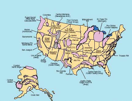
The goal of this project is to determine the location of "sweet spots" where basin centered gas resources are most likely to be produced.
U.S. Geological Survey
Location:
Denver, Colorado 80225
The objective of this DOE/USGS co-funded project was to identify and characterize the geologic and geographic distribution of basin-centered gas accumulations throughout the U.S., including Alaska, and analyze their potential significance to future natural gas exploration and development. This project utilized state-of-the-art procedures and knowledge of basin-centered gas systems, including, stratigraphic analysis, organic geochemistry, basin thermal dynamics and reservoir and pressure analyses. For each potential accumulation, this information was used to assess the existence of a basin-center gas and to map areas of favorable production characteristics (sweet spots) of the accumulation considered to have the best resource potential.
This completed project has served as an important source of information to both industry and government organizations concerned with developing appropriate strategies for recovering natural gas from reservoirs within basin-centered accumulations in the U.S. The final report on CD-ROM, available from DOE/NETL has been a sought-after source of information for many years following completion of the project.
and Remaining Tasks:
This project has been completed and a final report submitted to DOE. The report includes a digital map showing all defined basin centered gas systems for the U.S., documentation of geologic characteristics, identification of "sweet spots" and recommendations to industry and government for further development.
$349,499
$0
NETL - William Gwilliam (304-285-4401 or william.gwilliam@netl.doe.gov)
USGS - Vito Nuccio (303-236-5730 or vnuccio@usgs.gov)
Final Report - [PDF - 3110KB] Basin Centered Gas Systems of the U.S.
Studies of Natural Gas Resources in Deep Sedimentary Basins- Phase I Report [PDF]

