
Business

Business
Accelerate the development of methodologies for converting anomalously pressured gas resources in low-permeability gas formations to tangible energy reserves. The objective was to assemble and integrate information that will aid producers in avoiding the problems typical of gas production from low permeability reservoirs, through the application of a new exploration technology.
Innovative Discovery Technologies (IDT) – Project management and all research products
Location:
Laramie, WY 82072
Anomalously pressured gas reserves in low permeability formations are a huge domestic energy resource. However, the conversion of this resource to reserves has been disappointingly slow and costly. Experience has shown that conventional exploration techniques fail because commercial anomalously pressured gas accumulations in “tight” formations are not necessarily confined to conventional structural or stratigraphic traps.
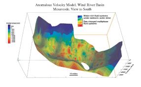
This project focuses on construction of a 3-D model of the Wind River Basin for the Tertiary and Mesozoic units and demonstrates how the application of a new methodology can provide, prior to drilling, information essential to choosing optimal drilling locations (e.g., spatial distribution of gas-charged rock/fluid systems including pressure compartment boundaries, location and nature of the regional pressure surface boundary, orientation and timing of faults, and location and spatial distribution of microfracture swarms). By assembling and integrating this information, producers can pick locations that avoid the standard problems of gas recovery from low permeability reservoirs (excessive water production, formation damage and problems associated with incompatible fluids).
This project developed the first basin-wide model of its kind. This model is available to all operators in the Wind River Basin and provides them the opportunity to review the location of their leases with areas of predicted anomalously pressured gas accumulations which they may have missed in their work. This model can be used as a starting point to do more detailed analysis for operators in their areas of interest.
The economic impact of this project is similar to those results from a detailed study done in the Jonah Field. In that application, the estimated ultimate recovery (EUR) of wells, drilled an average of 2 Bcf. At $4/MCf, this translated into an increased benefit of $8,000,000 per well. For just 20 wells drilled, the potential benefit was an increase in gross revenue of $160,000,000, whereas the cost to apply the technology was $800,000. Thus the cost/benefit ratio based on the 20 well example was 1/200. Applying this to an entire basin could possibly increase the benefit even greater.
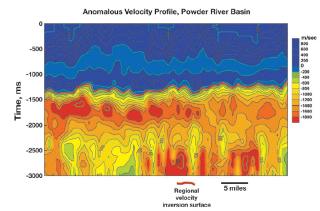
An anomalous velocity model was constructed for the Wind River Basin (WRB) based on ~2000 miles of 2-D seismic data and 175 sonic logs (a total of 132,000 velocity/depth profiles). Ten cross sections were constructed through the model coincident with known gas fields. In each cross section, an intense anomalously slow velocity domain was found to coincide with the gas productive rock/fluid interval.
An anomalous velocity model was developed that divides gas-charged rock/fluid systems (characterized by anomalously slow velocities) from water-rich rock/fluid systems (characterized by normal velocities). The model also delineates the regional velocity inversion surface, which is characterized by steepening of the Ro/depth gradient, a significant increase in capillary displacement pressure, a significant change in formation water composition, and acceleration of the reaction rate of smectite-to-illite diagenesis in mixed-layer clays.
Beneath the surface are significant fluid-flow compartments, which have a gas-charge in the fluid phase and are isolated from meteoric water recharge. Water-rich domains were found to occur within these regional gas-charged compartments, but were not being recharged from the meteoric water system (i.e., trapped water). The WRB was determined to be divided into at least two regionally prominent fluid-flow compartments separated by the velocity inversion surface: a water-dominated upper compartment likely under strong meteoric water drive, and a gas-charged, anomalously pressured lower compartment. Judging from the cross sections, numerous gas-charged sub-compartments occur within the regional compartment, the boundaries of which are controlled by faults and low-permeability rocks. The model shows that commercial gas production results when a reservoir interval characterized by enhanced porosity/permeability intersects one of these gas-charged sub-compartments.
The rock/fluid characteristics of the Rocky Mountain Laramide Basins (RMLB) described in this project determine the potential for significant “basin-center” hydrocarbon accumulations. If such accumulations occur, they will be characterized by the following critical attributes:
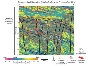
Because some of the identified critical attributes are not associated with conventional hydrocarbon accumulations, a new set of diagnostic tools is required to efficiently and effectively explore for and exploit this type of gas prospect. These new diagnostic tools have been discussed in a number of publications that resulted from this project.
This project is completed.
$1,058,250
$490,647
NETL – Gary Covatch (gary.covatch@netl.doe.gov or 304-285-4589)
IDT – Ronald C Surdham (rcsurdam@idt.bz or 307-745-4476)

