Business

Business
The objectives of the project include a field and laboratory study of the properties that control hydrocarbon occurrence in the Appalachian Basin. The goal is to develop a more accurate picture of the region's reservoir architecture that could reveal underground formations where producible oil may be trapped.
University of Tennessee
Knoxville, TN
United States Geological Survey (USGS),
Colorado Springs, CO
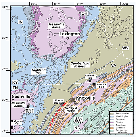
Previous work by the University of Tennessee and USGS led to significant discoveries in the Appalachian region in an area comprising eastern Tennessee, south-western Virginia, eastern Kentucky, and southern West Virginia. These discoveries may open up major exploration possibilities in geologic settings largely written off by the major oil companies in the 1980s. Most of the known reservoirs in the Appalachian Basin are located in the undeformed Plateau region, two are in the Thrust Belt in Tennessee, and several are in Virginia and West Virginia.
The geological work will include stratigraphic analysis, structural modeling, conodont analysis, geophysical interpretation, and vitrinite reflectance.
Results
The project is using the geologic, chemical and thermal history of the southeastern Appalachian Basin to predict the location of new oil-bearing formations that have eluded previous exploration and to develop models for future exploration.
Benefits
Identification of potential oil-bearing reservoirs in the southeast Appalachian Basin will provide independent operators in the region access to drilling and exploitation opportunities for oil and gas in underexplored areas. The significance of the project has been the discovery of the potential for oil in the footwall deformation of Appalachian fold structures and identification of fairways beneath the Cumberland Plateau and Highland Rim.
Summary
In the investigation of geologic controls of hydrocarbon occurrence in the southern Appalachian Basin, project researchers:
The drilling success rate for the Appalachian Plateau has been only 17% for development wells and 10-12% for wildcat wells. Recent production from two fields- Rose Hill and Swan Creek-piqued interest in the hydrocarbon potential of over-thrust formations in the Appalachian Basin. The Petroleum System Approach was used to study the lower Cambrian Rome Formation in Rome Trough in Kentucky; the Ordovician Knox Group, which is the source of gas at Swan Creek; and the Middle Ordovician and Mississippian carbonates in the fold belt and beneath the plateau.
A USGS study of Appalachian Basin conodonts, undertaken in connection with the project, used the Conodont Alteration Index (CAI), which is based on color changes caused by temperature and pres-sure. CAI has proved to be a valuable key to identification of oil and gas presence, and mapping for predictive modeling and drilling targets can be based on conodonts.
The project brought to light the previously unexplored Eureka structure, an 80 km long structure just east of the Eastern Cumberland escarpment. A single well drilled in the 1990s by a major oil company was abandoned without adequately exploring the potential of the area due to low oil prices at the time, despite shows of both oil and gas. The current study has found that the Eureka structure consists of a blind anticline beneath the surface thrust complex. The graben structure in the Appalachian Valley and Ridge is analogous to rock structure in the eastern Lubin Basin, Poland.
Vertical seismic profile (VSP) logs could provide the data necessary to identify the sweet spots in potential plays throughout the region. However, no seismic surveys currently are being conducted in the area, because they are too costly for the small independents who operate there. One goal of the project is to encourage exploration in the Appalachian Basin by demonstrating where seismic surveys and VSP analysis will be the most likely to provide drilling targets to larger independent operators.
The study identified drilling targets in the Ordovician Knox, Stones River, and Nashville Groups. More than 10 plays analogous to the Swan Creek field success were identified in Ordovician age rocks in the Appalachian Basin during the project. Previous oil exploration in the region has been limited to younger formations.
(December 2005)
Presentations were made at the AAPG Annual Meeting in Calgary in June 2005 summarizing the results of the investigation of hydrocarbon reservoirs in the Southern Appalachian Basin and the use of conodonts for prediction of reservoir quality. A summary presentation was made at the Eastern AAPG in Morgantown, WV, in October 2005 [PDF-1.87MB].
Funding
This project was selected under the Broad-Based Agency Announcement Round 2, DE-PS26-01NT-41048.
$537,263
$134,316 (20% of total)
NETL – Virginia Weyland (virginia.weyland@netl.doe.gov or 918-699-2041)
U. of Tennessee – Robert Hatcher (bobmap@utk.com or 865-974-6565)