Business

Business
The project goal is to develop innovative seismic-based methodologies and workflows to visualize and map reservoir compartments in order to better locate vertical and/or horizontal wells for improved recovery of oil and gas from complex karst-modified carbonate reservoirs within the onshore continental United States. The project objectives are to 1) calibrate new multi-trace seismic attributes for improved imaging of hydrocarbon reservoirs, 2) develop attribute-based, cost-effective workflows to better characterize karst-modified (compartmentalized) carbonate reservoirs and fracture systems, and 3) improve accuracy and predictiveness of geomodels by simulating history matches of well performances.
University of Kansas Center for Research, Lawrence, KS
Kansas Geological Survey, Lawrence, KS
Allied Geophysical Laboratories, University of Houston, Houston, TX
University of Oklahoma, Norman, OK
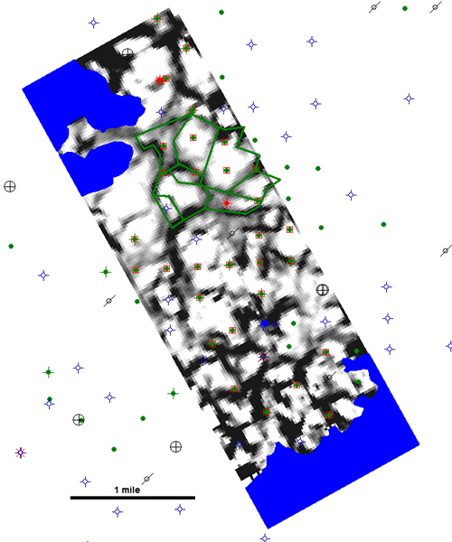
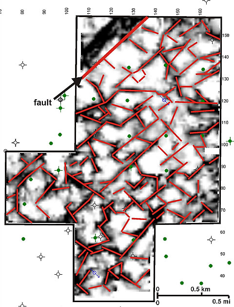
Karst-modified carbonate reservoirs account for 30-50 percent of the hydrocarbon production in the U.S. Midcontinent. These reservoirs are often characterized by low matrix permeability, fluid control problems, and low hydrocarbon recoveries. Fractures are important controls on development of permeability and hydraulic flow units in karst reservoirs and can produce significant reservoir compartmentalization. New technology is critical to the optimization of production from karst-modified reservoirs, and the project’s new multi-trace, geometric seismic attributes have the potential to image karst sinkholes, field-scale fracture systems and reservoir compartments, and other usually elusive subseismic features using relatively low-cost, conventionally acquired 3-D seismic surveys. In order to advance this imaging technology for the development and management of karst-modified reservoirs, these attributes must be calibrated at the field scale, i.e, used to match recorded well production/pressure histories. In this project, researchers are calibrating attributes from Midcontinent karst-modified reservoirs in West Texas, Colorado, and Kansas, that represent a wide diversity of karst types and validating their results through reservoir simulation and targeted infill drilling in select compartments.
The major deliverables from this project include:
Demonstration of the above workflow was carried out within the study areas where well-level data was available to a) characterize reservoir compartments, b) develop an integrated reservoir model, c) use reservoir simulation to validate the size and location of compartment boundaries, and d) identify undrained or partially drained reservoir compartments for targeted infill drilling. The demonstrations can used as a guide for implementing the workflow in other reservoirs.
Successful application of the results of this research will have the potential for incremental recovery of hydrocarbons from karst-modified reservoirs within the onshore continental United States by improving the imaging and understanding of complex and compartmentalized karst reservoirs.
The project website (http://www.kgs.ku.edu/ SEISKARST) provides timely, wide-audience dissemination of information related to the project. Also, several abstracts have been submitted for presentations at regional and national conferences.
(July 2009)
The project ended on March 31, 2009, and currently the researchers are in the process of compiling all relevant data and analyses into a final report for submission to DOE.
$799,833
$297,770 (27% of total)
NETL - Chandra Nautiyal (Chandra.Nautiyal@netl.doe.gov or 281-494-2488)
University of Kansas - Saibal Bhattacharya (saibal@ku.edu or 785-864-2058)
Publications
Nissen, S. E., Carr, T. R., Marfurt, K. J., and Sullivan, E. C., in press, Using 3-D seismic volumetric curvature attributes to identify fracture trends in a depleted Mississippian carbonate reservoir: Implications for assessing candidates for CO2 sequestration, in M. Grobe, J. Pashin, and R. Dodge, eds., Carbon Dioxide Sequestration in Geological Media - State of the Art, AAPG Special Publication.
Nissen, S. E., Doveton, J. H., and Watney, W. L., 2008, Petrophysical and geophysical characterization of karst in a Permian San Andres reservoir, Waddell field, West Texas, abstract, AAPG Annual Convention.
Carr, T. R., and Nissen, S. E., 2007, Application of curvature attributes to Kansas subsurface data, abstract, AAPG Midcontinent Convention.
Nissen, S. E., Sullivan, E.C., Marfurt, K.J., and Carr, T.R., 2007, Improving reservoir characterization of karst-modified reservoirs with 3-D geometric seismic attributes,” abstract, AAPG Midcontinent Convention.
Nissen, S. E., Carr, T. R., and Marfurt, K. J., 2007, Using new 3-D seismic attributes to identify subtle fracture trends in Mid-Continent Mississippian carbonate reservoirs, RMAG-DGS 13th Annual 3-D Seismic Symposium expanded abstract (also published in Geophysical Society of Kansas May-June newsletter: http://gsks.seg.org/newsletter/MAY-JUN07.pdf).
Sullivan, C., Nissen, S., and Marfurt, K., 2006, Application of volumetric 3-D seismic attributes to reservoir characterization of karst-modified reservoirs, in Slatt, R. M. et al., Eds., Reservoir Characterization: Integrating technology and business practices, 26th Annual GCSSEPM Foundation Bob F. Perkins Research Conference Proceedings, p. 409-428.
Rocke, B. J., 2006, Paleokarst morphologies of the Arbuckle Group and karst reservoir implications on the Central Kansas uplift, Russell and Barton Counties, Kansas, Master’s Thesis, The University of Kansas, Lawrence, 210 p.
Givens, N. B., 2006, An integrated study delineating karst and fracture features affecting reservoir performance in a Mississippian reservoir, Cheyenne County, Colorado, Master’s Thesis, The University of Kansas, Lawrence, 570 p.
Givens, N. B., and Nissen, S. E., 2006, Fracture and karst features affecting reservoir performance in a Mississippian reservoir, Cheyenne County, Colorado, Kansas Geological Survey Open-file report, 2006-14. http://www.kgs.ku.edu/PRS/publication/2006/2006-14/index.html
Sullivan, E. C., Nissen, S., Marfurt, K. J., and Blumentritt, C. H., 2006, Application of new seismic attributes to identify karst and fracture related compartmentalization: Permian San Andres Formation, Central Basin Platform, West Texas (USA), abstract, AAPG Annual Convention
Nissen, S. E., Bhattacharya, S., Doveton, J., and Watney, W. L., Semi-Annual Scientific/Technical Report, December 2007.
Nissen, S. E., Bhattacharya, S., Doveton, J., and Watney, W. L., Semi-Annual Scientific/Technical Report, June 2007, http://www.kgs.ku.edu/SEISKARST/DE_FC26_04NT15504_Jun07_semiannual.pdf.
Nissen, S. E., Watney, W. L., Givens, N. B., and Rocke, B. J., Semi-Annual Scientific/Technical Report, November 2006.
Nissen, S.E., Givens, N.B., Doveton, J.H., Byrnes, A.P., Rocke, B.J., Bhattacharya, S., and Sullivan, E.C., Semi-Annual Scientific/Technical Report, May 2006, http://www.kgs.ku.edu/SEISKARST/reports/DE_FC26_04NT15504_May06_semiannual.pdf.
Nissen, S. E., Sullivan, E. C., and Givens, N. B., Semi-Annual Scientific/Technical Report, November 2005, http://www.kgs.ku.edu/SEISKARST/reports/DE_FC26_04NT15504_Oct05_semiannual.pdf.
Nissen, S. E., and Sullivan, E. C., Semi-Annual Scientific/Technical Report, April 2005, http://www.kgs.ku.edu/SEISKARST/DE_FC26_04NT15504_April05_semiannual.pdf.