Business

Business
The goal of this project is to provide scientific data to aid in the total maximum daily load (TMDL) regulatory decision making process by developing data on watershed pollutant transport and contaminant sources for assessing the effectiveness of different water quality management strategies, and modeling the hydrologic cycle in the Dominguez Channel Watershed that includes the city of Los Angeles, and the Los Angeles and the Long Beach harbors.
Lawrence Berkeley National Laboratory (LBNL), Berkeley, CA
Lawrence Livermore National Laboratory (LLNL), Livermore, CA
This project is part of a process that will encourage the use of sound science in developing TMDL requirements for pollutants in the Dominguez Channel Watershed. A TMDL is a water quality standard defined by the EPA. The TMDL process refers to a plan for development and implementation of actions needed to comply with EPA standards. California is in the process of developing TMDLs for several water bodies, including the Dominguez Channel Watershed. Stakeholder groups involved in developing the TMDL include the California Region Water Quality Control Board, major industrial dischargers, and environmental organizations. Refiners and producers have an interest because they hold water discharge permits. In the past, pollutants in watersheds were controlled by reducing the permitted levels. Since the watersheds are still in non-compliance, the TMDL reduction will be the responsibility of both point sources (regulated industry with water permits) and non-point sources (including cities and harbors). The modeling results from this project will assist in establishing appropriate TMDLs for the Dominguez Channel Watershed.
Results
Among the accomplishments to date, the LBNL-LLNL researchers have:
Benefits
The work performed in this study allows for an improved understanding of hydrologic cycling through the use of the coupled Dominguez Channel surface-subsurface, streamflow, and water quality models (HSPF, CLM.PF). With better knowledge, policymakers can address interest groups and businesses, such as oil and gas industry operations, that want specific areas or projects excluded from regulations. (The Los Angeles-Long Beach harbors and watershed area is a major center of oil production and refining.) The streamflow and water quality models will improve clean-up rates and provide a basis for decision making and watershed management. The framework of the model system and its technical transferability will allow evaluation of the impact of conditions from year to year and from harbor to harbor to develop better strategies for contaminant management.
Summary
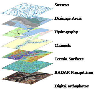
The LBNL-LLNL research team developed a two-track approach for quantifying TMDLs for heavy metals by 1) implementing EPA’s Hydrologic Simulation Model—FORTRAN (HSPF), along with high-resolution RADAR precipitation observations, and 2) an advanced, physically based surface-groundwater model (CLM.PF), both in the Dominguez Channel Watershed above the tidal zone (Figure 1a). Along with the modeling effort, the team has participated on the Port of Los Angeles/Long Beach Science Review Board for TMDLs.
Management of surface water quality is often complicated by interactions between surface water and groundwater. Traditional Land-Surface Models (LSMs) used for numerical weather prediction, climate simulation, and as inputs to water management decision support systems, do not treat the lower boundary in a fully process-based fashion. LSMs have evolved from a leaky bucket to more sophisticated land surface water and energy budgets that typically have a so-called basement term to depict the bottom model layer exchange with deeper aquifers. Nevertheless, the LSM lower boundary is often assumed at zero flux, or the soil moisture content is set to a constant value. This approach, while mass conservative, ignores processes that can alter surface fluxes, runoff, and water quantity and quality. Conversely, models for saturated and unsaturated water flow, while addressing important features such as subsurface heterogeneity and three-dimensional flow, often have overly simplified upper boundary conditions that ignore soil heating, runoff, snow, and root-zone uptake.
An initial set of simulations based on data from the Project for Intercomparison of Land-Surface Parameterization Schemes (PILPS) in Valdai, Russia, and synthetic data has been completed. The simulations demonstrate the temporal dynamics of both of the coupled models. Changes in soil moisture and movement of the water table are used as indicators of conservation of mass between the two models. Sensitivity studies demonstrate the effects of precipitation, evapotranspiration, radiation, subsurface geology, and heterogeneity on predicted watershed flow. The coupled models will ultimately be used to assist in the development of TMDLs for a number of pollutants in an urban watershed in Southern California. Sensitivity studies will demonstrate the effects of watershed flow in uncoupled and coupled modes.
(February 2008)
All work activities on this project have been completed.
The LBNL-LLNL surface-groundwater model, CLM.PF (Maxwell and Miller 2005), has been developed from first principles as a mass conserving system. It has been implemented and tested as single column models using synthetic data as a stress and numerical stability test, and with observations from the Usad site in Valdai, Russia, indicating the importance of the physically-based model impacts on soil moisture. This new model development, along with a new integrated way of coupling surface and subsurface lateral flow capable of handling multiple processes related to runoff production (Kollet and Maxwell 2006), and saturated conductivity estimations are viewed by the hydrometeorology community as significant contributions toward understanding the relationship between atmospheric variability and groundwater and soil moisture variations, critical terms for quantitatively computing TMDLs.
The project work completed included the remaining tasks below:
Funding
This project is funded under the Petroleum Environmental Solutions Program. LLNL conducted research and complemented this effort under contracts FEW 0129 and FEW 0145.
$952,000
$225,000 (19% of total)
NETL – Jesse Garcia (jesse.garcia@netl.doe.gov or 918-699-2036)
LBNL - Norm Miller (NLMiller@lbl.gov or 510-495-2374)
LLNL - Reed M. Maxwell (maxwell5@llnl.gov or 925-422-7436)
Publications
Outreach with and presentations to Western States Petroleum Association, EPA, the ports of Long Beach and Los Angeles, and other Dominguez Channel stakeholders.
Project-specific Peer Reviewed Journal Publications
Maxwell, R.M. and N.L. Miller, 2005: Development of a coupled land surface and groundwater model, Journal of Hydrometeorology, 6, 233-247.
Kollet, S.J. and R.M. Maxwell, 2006: Integrated surface-groundwater flow modeling: A free-surface overland flow boundary condition in a parallel groundwater flow model. Advances in Water Resources, 29, 945-958.