
Business

Business
The overall goal of this project is to significantly increase oil production under the ethic of "least social, environmental, and economic impact." Three objectives support that goal:
Alaska Department of Natural Resources (DNR)
Anchorage, AK
Alaska Oil and Gas Conservation Commission (AOGCC)
Anchorage, AK
Alaska has nearly one quarter of the Nation's reserves of crude oil, at least five billion barrels of proven reserves. The American Association of Petroleum Geologists reports that the 1995 National Assessment identified the North Slope as having 7.4 billion barrels of technically recoverable oil and over 63 trillion cubic feet of natural gas. From these reseources, Alaska accounts for roughly one fifth of the nation's daily crude oil production, or almost 1 million barrels per day from over 1,800 active wells. Total daily production peaked in the late 1980s, and declines have been limited through the addition of new fields and new extraction technologies for existing fields.
The number of exploration wells drilled per year in Alaska must dramatically increase to increase oil production. A strategy to support this goal is to increase the number of active independents operating under lease. As of February 2004 there were 27 independent oil companies operating in Alaska. One independent went from lease issuance to permits in hand for a North Slope offshore well in 3 months.
Permit streamlining supported through this grant builds upon the institutional and regulatory changes implemented by the State of Alaska. Currently, State agencies use multiple, independent systems to identify, authenticate, and authorize customers for online transactions. Consumers of online State services may be required to manage multiple online "profiles," and during a permit review process, valuable time related to short field study windows may be lost reconciling differences in applicant information when agency records disagree. This project advances the concept of a unified permit and sets the framework and foundation for its implementation.
Project Results
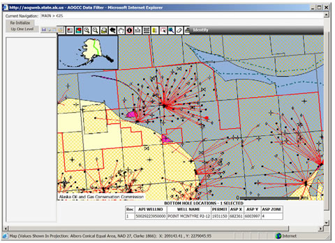
The project has advanced technologies to expand public access to geo-technical information. The Alaska Oil and Gas Conservation Commission is the repository for production and well information for Alaska’s oil and gas wells. An important part of the Commission’s mandate is to provide the non-confidential portion of well and production data to the public. Past practice has consisted of allowing members of the public to come to the Commissions office to view and copy the information.
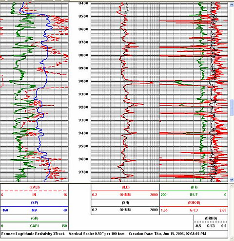
Over 5500 wells and 800,000 documents have been electronically entered into the public domain via the Internet. Statewide searches and downloads are supported, including geographic based searches, with the most complete data for Alaska’s leading oil and gas basins, Alaska North Slope and Cook Inlet. Previously, well logs from wells drilled prior to 1986 were available to the public only as paper versions stored in a central Anchorage office. Digital versions of most of those well logs have been acquired for public distribution through the commission’s website. Public acceptance of the new geo-technical web site has been positive and customer feedback continues to help guide site improvements. This effort offers automated map-based searches to directional data, well header information, well history files, log files, well production data, administrative and field files, and commission orders. The applications use a shared GIS model which eliminates the need to duplicate spatial data. On-line self-help training videos help guide new users through a comprehensive training program. Detailed Alaska Well and Production Data are now available at: http://alaska.gov/.
A new on-line permitting system has been advanced. The solution is centered on a shared decision support environment to reduce project review cycle time. Coastal Consistency Reviews will be automated in this new shared environment in early 2006, Land Use Permits required for surface use permits related to environmental controls will follow.
Benefits
The Arctic is a challenging work environment making it difficult to attract new players to mature fields. Despite these challenges, state oil and gas lease offerings are attracting exploration and production companies new to the state. Declines in the Prudhoe Bay, Kuparuk River and other fields have been offset in part by development of neighboring satellite fields, helping to maintain steady revenues to both producers and resource owners. The role of independents in this effort to increase production has steadily increased in recent years.
Drilling of new exploration wells exceeded the DNR Oil and Gas management goal. In the second quarter FY06, eighteen (18) exploration wells were proposed, eleven (11) were permitted, and seven (7) are pending conclusion of review periods.
Structural changes led by the Governor and senior resource managers have helped to streamline the permit process. This new regulatory process is now being captured in an automated on-line system that will support shared standards and collaborative decision making. These changes have helped to simplify the program, clarify requirements, and eliminate redundancies between agencies.
The Administration’s Permit Streamlining Accomplishments provide leadership in the area targeted by this grant. They include:
Project Summary
This project had made progress toward the goals by:
(June 2006)
On-Line Publication of Geo-Technical Data has met the goals and the schedule. The majority of public geotechnical publications with GIS search capability are currently available through the Alaska Oil and Gas Conservation Commission web site at http://alaska.gov/. Recently acquired pre-1986 well log data was added in March 2006.
Automation of the Coastal Consistency Review and Land Use Permit process is being tested by the users. The application registers all users under a centralized state directory called MyAlaska. The application then guides users though the Coastal Project Questionnaire process through a series of questions aligned with the responsibilities of each agency. Users enter project location information based on USGS topographic maps, and the system automatically answers required questions such as “is the project on state land?” or “does the project fall within the Coastal Zone Management Units?” Up to fifteen required fields are automatically populated for the customer based on location. This simplifies the overall process for applicants. Upon completion of the modifications requested from the user testing, the application will be made available on the DNR web site; (dnr.alaska.gov). The administrations structural changes to the permitting process that took place over the past four years strengthen the overall goal of improved permitting and simplify the automation environment. On-line products will first move to production in summer 2006.
The goal to utilize geography as an organizing principle for multiple agencies remains on track. Enterprise GIS components went into production during the last quarter of 2003 and into the first quarter of 2004 using open GIS standards supported through the Oracle spatial data object geometries model. A distributed multi-agency GIS is part of the AOGCC support of geo-technical and lease boundary publication and is used to simply the CPQ requirements for applicants by answering required questions based on project location. Spatially capable permitting applications and query tools are central to delivery of permit automation goals.
$1,393,600.
$601,100 (30.1% of total)
Other Government Organizations Involved
Alaska DNR
AOGCC
NETL - John Ford (john.ford@netl.doe.gov or 918-699-2061)
DNR - Richard McMahon (richard_mcmahon@dnr.State.ak.us or 907-269-8836)
AOGCC - Robert Crandall (bob_crandall@admin.State.ak.us or 907-793-1221)
Publications
Semi-Annual Technical Reports have been filed with DOE.

