Business

Business
The objective of this research is to develop approaches to quantify air quality impacts of oil and gas exploration and production in the western United States.
Lawrence Berkeley National Laboratory (LBNL), Berkeley, CA
Major problems addressed by the project are the air quality issues associated with visibility, ozone, and PM-2.5 (aerosols/particles of less than 2.5 microns in size) in the West where oil and gas exploration and production occur. The project began when oil and gas production was threatened by concerns over air quality in southwest Wyoming. LBNL made an extensive study of the Southwest Wyoming Task Air Forum (SWYTAF) modeling effort, and raised a number of concerns. LBNL has performed time series, regression, and correlation analyses of aerosol and meteorological data taken at Class I sites in the Central Rocky Mountain region. Studies of public perceptions of model uncertainty were also the topic of a Ph.D thesis supported by this project. Considerable work in the area has also raised issues of ammonia (NH3) limitation and questioned the appropriateness of a nitrogen oxide (NOx) reduction rule and analysis procedures used to quantify visibility. LBNL researchers have also examined the Interagency Monitoring of Protected Visual Environments (IMPROVE) database to determine the types of aerosols responsible for the 20 percent dirtiest days in Colorado and Wyoming over a more than 10-year period. The project performers’ work on air quality modeling is also beneficial to the Western Regional Air Partnership (WRAP) and several other government agencies. LBNL participated in a number of WRAP committees: the Modeling Forum, the Emissions Forum, and the Fire Emissions Forum. Recently, researchers have examined the influence of remote forest fires on regional aerosol loading, visibility impairment, and ozone.
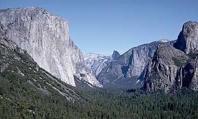
Significant oil and gas exploration and production occur in the Central Rocky Mountain and California Central Valley regions. Air quality issues of greatest concern are visibility, PM-2.5, and ozone exceedances. Ozone and PM-2.5 impact health and affect climate. Aerosols are formed and transported from populated and industrial areas, forests, wildfires, and production sites. Visibility impairment is primarily caused by light scattering and light absorption of ambient particulate matter while the extent of light extinction (scattering + absorption) is governed by particle chemical composition and particle size distribution. As the ambient relative humidity (RH) varies, the change of particle size owing to the water uptake or loss by hygroscopic aerosols influences the light scattering properties, thereby affecting visibility.
Air quality modeling is used to predict spatially and temporally dependent concentrations of ozone and PM. Modeling results are used to determine visibility, source apportionment, ozone responses to precursors, and to suggest possible control strategies. Consequently, it is important to have modeling systems for specific geographic areas that are accurate. We have performed research on particle growth rates that is useful for developing reliable models for aerosol concentrations. Calculated aerosol concentrations must be converted to a “visibility degradation metric.” For this quantity to be calculated correctly, a measurement of RH and the dependence of visibility on RH must be known. LBNL researchers have conducted extensive data analysis to determine scattering efficiencies of different types of aerosols as a function of RH using highly time-resolved data collected by LBNL as part of a separate study supported by DOE. LBNL has also averaged the results over different time periods to determine the effects of the averaging times that have been proposed. Another requirement of the Regional Haze Rule is that visibility be restored to natural conditions. Important to this debate is determining the relative contributions of natural and anthropogenic influences. The research on the regional influence of wildfires is responsive to this. Kern County, where oil and gas exploration and production occur, is out of compliance with both the ozone and PM-2.5 standards. It is likely to be an area where NOx reductions are mandated; hence modeling of the air quality in this area and using the modeling results to understand ozone and PM sensitivity to precursors is important for designing control strategies. These require models that perform with acceptable accuracy.
LBNL has conducted a detailed evaluation of the seasonal and episodic performance of the Community Multiscale Air Quality (CMAQ) modeling system applied to simulate air quality at a fine grid spacing (4 km horizontal resolution) in central California, where ozone air pollution problems are severe. LBNL has also examined ozone production and transport from forest fires. LBNL refined their approach for calculating scattering efficiencies as a function of RH using more highly time resolved chemically speciated particle concentrations and RH data. LBNL made an extensive study of the SWYTAF (Southwest Wyoming Task Air Forum) modeling effort and raised a number of concerns regarding the viability of the modeling approach. As a result, the modeling results were not very influential in informing public policy.
Other project accomplishments are as follows:
Cluster analysis was applied to daily 8h ozone maxima, modeled for a summer season to characterize meteorology-induced variations in the spatial distribution of ozone. The first three principal components (PCs) capture ~85% of total variance, with PC1 describing a general spatial trend, and PC2 and PC3 each describing a spatial contrast. Six clusters were identified for California’s San Joaquin Valley (SJV) with two low-, three moderate-, and one high-ozone cluster. The moderate-ozone clusters are distinguished by elevated ozone levels in different parts of the valley: northern, western, and eastern, respectively. The SJV ozone clusters have stronger coupling with the San Francisco Bay area (SFB) than with the Sacramento Valley (SV). Variations in ozone spatial distributions induced by anthropogenic emission changes are small relative to the overall variations in ozone anomalies observed for the whole summer. Ozone regimes identified here are mostly determined by the direct and indirect meteorological effects. Existing measurement sites are sufficiently representative to capture ozone spatial patterns in the SFB and SV, but the western side of the SJV is under-sampled.
(November 2010)
This project has been completed.
$1,660,000
$50,000 (29 percent of total)
NETL – Sinisha (Jay) Jikich (sinisha.jikich@netl.doe.gov or 304-285-4320)
LBNL - Nancy J. Brown (njbrown@lbl.gov or 510-486-4241)
Publications
Ling Jin, Nancy Brown, Robert A. Harley, Jian-Wen Bao, Sarah Michelson, James M. Wilzak, Seasonal versus Episodic Performance Evaluation for an Eulerian Photochemical Model, in press Journal Geophysical Research Atmospheres (2009).
Sarah M. Sermondadaz, Ling Jin, Nancy J. Brown, 2009, ”Assessment of California wildfire effects on air quality,” abstract submitted for fall 2009 American Geophysical Union (AGU) meeting.
Lunden, M., Fine, J., Singer, B., Brown, N. J., Roth, P., and Reynolds, S., “Issues Concerned with Modeling Visibility,” Presented at the GRI Air Toxics Conference, San Antonio, TX, May 1999. Also LBNL Report No. 43562.
Lunden, M., Fine, J., Singer, B., Brown, N. J., Roth, P., and Reynolds, S., “An Assessment of the Air Quality Modeling Efforts in Southwest Wyoming,” June 1999, LBNL Report No. 44544.
Lunden, M., Fine, J., Singer, B., Brown, N. J., Roth, P., and Reynolds, S., “Summary of Assessment of the Air Quality Modeling Efforts in Southwest Wyoming,” November 1999, LBNL Report No. 45458.
Fine, J.D., L. Vuilleumier, S. Reynolds, P. Roth, and N.J. Brown, “Evaluating Uncertainties in Regional Photochemical Air Quality Modeling,” invited paper, Annual Review of Environmental Resources 28, 2003, pp. 59-106 (also Lawrence Berkeley National Laboratory Report No. 52222).
Fine, J.D., “The Ends of Uncertainty: Air Quality Science and Planning in Central California,” PhD thesis at the University of California-Berkeley (also Lawrence Berkeley National Laboratory Report No. 54222).
Lunden, Melissa, Douglas Black, Nancy J. Brown, Gavin McMeeking, Sonia Kreidenweis, Christian Carrico, Taehyong Lee, Jacqueline Carrillo, Jeffrey Collett, Jr., Derek Day, Jennifer Hand, and William Malm, "The Influence of Forest Fires in the Western US on Pollutant Concentrations in California during Summer of 2002," American Association of Aerosol Research, Atlanta, GA, 2004.
Brown, Nancy J., De Ling Liu, Melissa Lunden, and Shaheen Tonse, “Visibility, Aerosol Concentrations, and Relative Humidity,” American Geophysical Union, December 2004, San Francisco, CA.
Lunden, Melissa M., Nancy J. Brown, De Ling Liu, and Shaheen Tonse, “Analysis of the Effects of Chemical Composition and Humidity on Visibility using Highly Time Resolved Aerosol Data,” Presented at the American Geophysical Union Annual Fall Meeting, San Francisco, CA, December 2005 (LBNL-60871 Poster).
Lunden, M.M., D.R. Black, M. McKay, K.L. Revzan, A.H. Goldstein, and N.J. Brown, 2005, “Characteristics of Fine Particle Growth Events Observed Above a Forested Ecosystem in the Sierra Nevada Mountains of California,” Aerosol Science and Technology 40, pp. 373-388 (also LBNL-58135).
McMeeking, G.R., S.M. Kreidenweis, M. Lunden, J. Carrillo, C.M. Carrico, T. Lee, P. Herckes, G. Engling, D.E. Day, J. Hand, N. Brown, W.C. Malm, and J.L. Collett, Jr., 2006, Smoke-Impacted Regional Haze in California during the Summer of 2002, Agricultural and Forest Meteorology 137, pp. 25-42.