Business

Business
Program
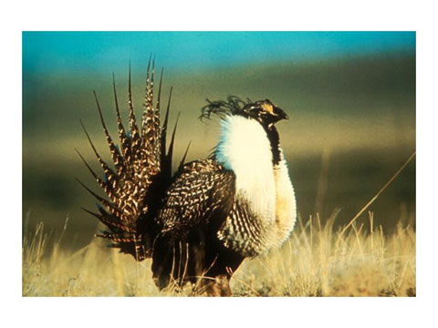
This project was selected as part of an Interagency Agreement through a Memorandum of Understanding (MOU) between DOE and the Bureau of Land Management (BLM) Federal Lands Technical Partnership. Project Goal Four specific tasks have been chosen to further the goal of public access to oil and gas development on Federal Lands: 1) 3M mapping, modeling and monitoring of the northern San Juan Basin, CO, 2) Assessment of brine impact on aquifers in Seminole County, OK, 3) Coalbed methane (CBM) water quality monitoring in WY, 4) Study effects of oil and gas development on sage grouse, mule deer and pronghorn (WY).
Bureau of Land Management, U.S. Department of Interior
Field offices: Durango, CO; Tulsa, OK; Casper, WY; Cheyenne, WY
BLM and DOE are working together to protect the environment while supporting the goal of increasing domestic oil and gas production. As the primary manager of Federal Lands, BLM has the responsibility to balance the many public uses of the land, including oil and gas production, with environmental protection. Because of the need to protect varying interests, a cumbersome system of stipulations and permitting requirements has evolved that effectively limit oil and gas development. Many of these stipulations, however are based on historical industry practices and do not consider current or new innovative industry capabilities to minimize disturbance, protect the environment, and to minimize aesthetic impacts. Other restrictions result from assumptions about environmental protection standards and/or pollution from oil and gas activities that have never been verified by research. The four tasks of the BLM/DOE interagency agreement are aimed at helping resolve issues that affect access to Federal Lands for oil and gas operations.
Project Results
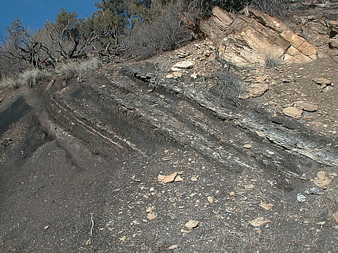
The 3M study provided validation of field data necessary to design a well monitoring program for the San Juan Basin. The study demonstrated that methane seepage along outcrops will increase with further coalbed methane development in the San Juan Basin. In Seminole County, OK brine leakage from oil field operations dating back to 1900 have been mapped.
The water quality monitoring project in the Powder River Basin established guidelines and methodology for future monitoring of CBM produced water flow and infiltration into the subsurface.
The Sage Grouse study in western WY is a critical issue. Sage grouse populations were evaluated for possible inclusion on the Endangered Species list. Data provided by this project will assist Federal Agencies in making that determination.
Benefits
The studies have provided models, and data critical to support land use decisions for Federal Agencies, County and State planners in four western states (Colorado, New Mexico, Oklahoma and Wyoming). Data gathering and research on CBM, abandoned oilfield sites and animal populations provide valuable scientific evidence on past and potential future effects of oil and gas development on water quality, soil remediation and habitat disturbance. The information is used to inform the public of scientific facts concerning specific topics, which have generated controversy and/or misinformation from private groups or individuals.
Project Summary
The 3M project in the San Juan Basin has assessed the methane seepage impact related to the closer spacing of Fruitland CBM wells from 320-acre spacing to 160-acre spacing. The research on the potential methane seepage at the outcrop is the first to quantify the seepage rates and tie them to production activities in the basin.
$335,000
$150,000 (39% of total)
Other Government Organizations
Involved Bureau of Land Management, Department of Interior
NETL - David Alleman (david.alleman@netl.doe.gov or 918-699-2057)
BLM - Tom Hewitt (tom_hewitt@blm.gov or 202-452-0378)