
Business

Business
The goal of this project is to overcome existing water-related environmental barriers to possible oil shale development in the Uinta Basin, Utah. Data collected from this study will help alleviate problems associated with disposal of produced saline water, which is a by-product of methods used to facilitate conventional hydrocarbon production.
Utah Geological Survey, Salt Lake City, Utah, 84114
Collaborators
Saline water disposal is the single most pressing issue with regard to increasing petroleum and natural gas production in the Uinta Basin in Utah. Conventional oil fields in the basin provide 69% of Utah’s total crude oil production and 71% of Utah’s total natural gas, the latter of which has increased 60% in the last 10 years (Utah Division of Oil, Gas and Mining, 2009). As petroleum production increases, so does saline water production, increasing the need for economic and environmentally responsible disposal plans. Current water disposal wells are near capacity and permitting for new wells is being delayed because of a lack of technical data regarding potential impacts to disposal aquifers and questions concerning contamination of fresh water sources. Many Uinta Basin operators claim that petroleum and natural gas production cannot reach its full potential until a suitable long-term, saline water disposal solution is found.
Currently, the agencies responsible for regulating the disposal of produced water use 20-year-old data amassed in a publication entitled “Base of Moderately Saline Ground Water in the Uinta Basin, Utah” to determine zones suitable for water disposal (Howells and others, 1987). This hard copy publication provides a paper map showing the depth of the transition between moderately saline and very saline water (10,000 mg/L). It is believed that saline water can be injected below this depth without damage to overlying fresh-water aquifers. Several oil and gas operators working in the basin believe this dated study requires substantial revision.
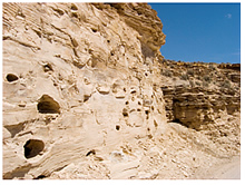
Eastern Uinta Basin gas producers claim that one of the only aquifers suitable for large volume saline water disposal is the Birds Nest aquifer located in the Parachute Creek Member of the Green River Formation (Figure 1). After an extensive literature search, it was determined that the Birds Nest aquifer is poorly understood and further study is necessary before large-scale saline water disposal can commence. The Birds Nest aquifer is typically several hundred feet above the richest oil shale interval called the Mahogany zone. A significant concern is that saline water disposal into the Birds Nest by conventional gas producers may hinder oil shale development by creating unforeseen economic and technical hurdles. In many areas containing rich oil shale deposits, the Birds Nest contains fresh to slightly saline water (Holmes and Kimball, 1987) (Figure 2). By increasing saline water discharge into the aquifer, the Birds Nest water quality could degrade, creating additional water disposal problems for oil shale development companies.
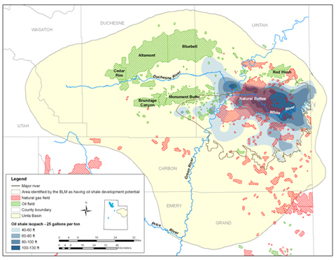
In addition to the water-related problems mentioned above, there is a regulatory need for baseline water quality and quantity data covering proposed oil shale development lands (Figure 2). Water-quality degradation could result from new oil shale developments via mining and surface retort or in situ processes. An up-to-date Geographic Information System (GIS) database would provide the baseline water information needed to understand potential impacts of future oil shale development.
Each successful part of this multi-faceted study will provide the information needed to achieve two goals: (1) alleviation of problems associated with produced saline water usage as a means to facilitate increased conventional hydrocarbon production, and (2) resolving environmental barriers to possible oil shale development.
By utilizing the newly developed GIS maps, regulators and oil and natural gas operators can make informed saline water disposal management decisions and protect freshwater resources. If new, appropriate, saline water disposal intervals can be identified that are similar to the Birds Nest aquifer, oil and natural gas production can continue to increase, supplying the nation’s growing demand with safe, convenient, domestic resources. Additionally, environmentally sound water management solutions for a future oil shale industry can be developed once the sensitivities of alluvial and bedrock aquifers within potential oil shale development regions are understood.
The project is completed. The final report is available below under "Additional Information".
$688,222
$172,056
NETL –Skip Pratt (skip.pratt@netl.doe.gov or 304-285-4396)
Utah Geological Survey – Michael Vanden Berg (michaelvandenberg@utah.gov or 801-538-5419)
Final Project Report [PDF-99.3MB]
Utah Geological Survey project website [external site]
Technology Status Assessment [PDF-126KB]

