
Business

Business
The goal of this project is to implement a snow control practice to enhance snow drift formation as a local water source to recharge a depleted lake despite possible unfavorable climate and hydrology preconditions (i.e., surface storage deficit and/or low precipitation).
University of Alaska Fairbanks, Fairbanks, AK
Snow is central to activities in polar latitudes of Alaska over a very significant part of each year. With the arrival of snow, modes of travel, working, and living are transformed. Oil and gas exploration operations restricted to winter months use ice roads and ice pads in arctic and subarctic regions. The general reasoning behind ice road construction is that, unlike gravel roads, they leave little or no trace behind and require no mitigation or reclamation activities once they are no longer used. A traditional water source for building ice roads is water withdrawal from area lakes. The Bureau of Land Management estimated that 3.8 million to 5.7 million liters (1 to 1.5 million gallons) of water is needed per mile to build an ice road 15 cm (6 inches) thick and 9-11 meters (30-35 feet) wide. A traditional ice road requires about a million gallons of water per mile. Current regulation allows withdrawing 15 percent of water from lakes with fish and taking all the water from lakes without fish. One concern that emerged through the North Slope Tundra Lake study—and now has become a central problem facing federal and state land agencies—is whether the lakes are completely recharged after being used.
The hydrological regime of Alaska’s Arctic Slope (AAS) lakes is characterized by a large spring snowmelt providing much of the recharge and subsequent drying of the lake in the summer, when evaporation generally exceeds precipitation. Some of the surface storage deficit is made up during the early fall period when precipitation is generally at an annual maximum while evapotranspiration is rapidly shutting down. Late summer precipitation may result in runoff from upland tundra areas to partially recharge pond storage. Depending on the available surface storage deficit (dry summer and fall), winter precipitation, and ablation rate, a pumped lake may or may not be filled to its full capacity by winter.
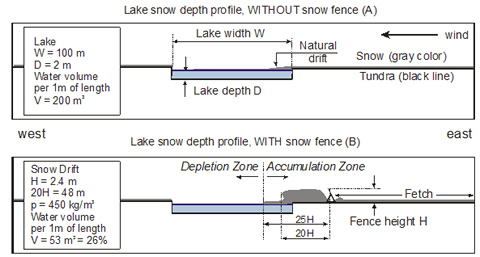
This project evaluates the use of snow management and snow fences to augment lake water supplies. Snow control practices will be implemented in order to enhance snow drift accumulation, which leads to decreased snow sublimation, increased melt water production, and an extended melting season that will recharge a depleted lake despite potentially unfavorable climate and hydrological conditions (i.e., surface storage deficit and/or low precipitation). Snow fences are widely used to control the amount of snow accumulated or eroded. They are designed to reduce wind speed, therefore causing snow to deposit in designated areas. The size and shape of snow drifts are quite distinctive and repeatable when wind direction is consistent, as is the case on Alaska’s Arctic Slope. Although snow fences can augment water supplies by altering snow distribution, they also make “new” water available by reducing the sublimation losses from blowing particles and erosion processes on large lakes. Up to twenty percent of the blowing snow sublimates over transport distances of 3000 meters (about 2 miles). In addition to enhanced accumulation and “new” snow, increased snow depth at the fence prolongs snowmelt and makes additional water available through mid-summer. It is important to note that the cost of additional water obtained by using snow fences appears to be very low. It has been reported that, based on data over a six-year period, if the snow fence and construction cost were amortized over 25 years, the cost of the water would be about $0.077 per cubic meter (thirty cents per thousand gallons).
Finding an optimum location for the snow drift would increase the probability that this snow will effectively recharge the lake through most of the summer. Specifically, UAF will construct a snow fence for two consecutive winters on AAS in the vicinity of Prudhoe Bay. Two lakes with similar water balances will be selected and monitored. One will be an experimental lake where a snow fence is installed; the second will be a control lake where the natural regime is preserved. This project will assess the snow fence’s effects on (1) ”new” water available due to reduced sublimation losses from blowing snow and decreased snow erosion on the lake; (2) duration of snowmelt runoff from the snow fence’s drift and its effect on lake water balance; (3) lake volume net increase; and (4) the cost, feasibility, and environmental consequences of this approach. These characteristics will be examined through a full suite of field observations, modeling and sensitivity analyses of snow transport by wind, and water balance assessment.
This project will yield practical insight on using artificial barriers to prolong additional melt water recharge to the lake systems. It is important to assess the effects of artificial barriers on “new” water available due to reduced sublimation losses from blowing particles and decreased snow erosion on the lake; increased duration of snowmelt runoff from the artificially created snow drift and its effect on lake water balance; lake volume net increase, and the cost of additional water. This research will lead to more efficient use of water resources for ice road and ice pad construction.
Researchers collaborated with the NSDSS team in to incorporate the additional water equivalent resulting from the snow fence into the water balance formulation. Project results were published by M. Sturm and S. Stuefer in a paper entitled “Wind-blown flux rates derived from drifts at arctic snow fences” in the current issue of the international peer-reviewed Journal of Glaciology. The article can be downloaded at http://www.igsoc.org/journal/59/213/.
Researchers investigated costs for snow fence materials, installation, and maintenance over time in order to better estimate total costs involved in additional water collection. A feasibility study was conducted on various soil types and snow fence designs to enable utilization of the snow fence application in areas throughout the North Slope. An M.S. student in structural engineering has begun to compare commonly used snow fence designs and will evaluate their performance in the seasonally and permanently frozen soils. Results of this analysis will be included in recommendations for increasing the performance of artificial barriers in the permafrost environment.
Dr. Stuefer incorporated the snow fence water estimator model into the North Slope Decision Support System (NSDSS), which was developed under DOE project DE-NT0005683 (North Slope Decision Support for Water Resource Planning and Management). Calculations of snow drift and additional water from drifts can be included in the NSDSS water balance model to help support water resource management decisions related to ice road construction.
Dr. Sveta Stuefer made a presentation at the 2012 American Water Resources Association Conference in Juneau which showed that during the 2011 snow season, the snow fence was responsible for an additional 1.8 million gallons of water at a cost of $.01 per gallon. In 2010, the snow fence added 1.5 million gallons of water at a cost of $.02 per gallon. In both 2010 and 2011, the snow fence extended the snow melt season resulting in an additional month of fresh water supply to the lake despite low precipitation levels.
The snow fence and all related equipment were removed from the experimental site in September 2011. Land use completion reports were prepared for the Northern Oil and Gas Division of Mining, Land & Water, Alaska Department of Natural Resources (DNR), the Planning and Community Services Department of North Slope Borough, and the Alyeska Pipeline Service Company.
A snow survey was completed in the last week of May 2011. Snow depths at both lakes were recorded and a snow density profile was used to estimate the total snow water equivalents. The open water season is estimated to begin on June 9, 2011, and last until late August. Updated water cost results will be calculated with the additional data. Based on preliminary snow melt calculations, an extra month of water was added to the experimental lake in 2011. The snow fence field site was inspected during a trip in March 2011. The weather tower was reporting data through telemetry and the snow fence had no reported damage.
Dr. Stuefer gave a presentation entitled “Snow Management to Augment Fresh Water Supplies in the Arctic” at the Arctic Technology Conference February 7–9, 2011, in Houston, Texas.
Hydrological data analysis showed the ability of the snow fence to add to the experimental lake water supply in summer 2010. Although rainfall was below normal, water levels in the experimental lake increased during the entire open-water season while the levels declined in the control lake. Three significant snow events were recorded in late 2010 with the largest one occurring in November. The installation of the snow fence at the experimental lake has added approximately two million gallons of water to the lake supply.
Research has shown that the installation of a snow fence reduces reservoir water loss due to snow sublimation. The resultant snow drift created by the snow fence has added an additional month of water to the lake supply that can be utilized for ice road construction. Water levels in the lake near the snow fence were elevated during the entire 2010 open water season.
Pretreatment water balance analysis for 2009 indicates that the majority of water loss was due to evaporation from the lake surface with only half of the water loss being replaced through summer rainfall. The cumulative rainfall in 2010 was below average and equaled only half the rainfall total for 2009. Water balance calculations indicate there is additional inflow into the man-made lake.
Snow drift elevation was measured twice in the summer of 2010 using high precision GPS instruments. Snow drift volume was calculated in 3-D Analyst using drift snow density averages. The estimated drift volume on June 21, 2010 was 5943 cubic meters (7773 cubic yards). The snow water equivalent (SWE) was estimated with the field data. A model was developed to estimate snow drift melt based on the continuous snow depth data obtained from three sonic depth sensors. The snow drift lost approximately 75 percent of its volume during the first three weeks of melt.
Major water sources and sinks were measured at the experimental and control lakes. Research accomplishments included the bathymetry survey, water level records, and measurements of the lake outflow, rain precipitation, evaporation, and water withdrawal from the gravel pit. A tower near the snow fence was equipped with a data logger, power, solar panel, camera, antenna, radio, and relative humidity and air temperature sensors to monitor snow drift growth and melt. The radio transmits all the data and camera images from the snow fence site to the Water and Environmental Research Center (WERC) server in real-time.
The automated data collection was initiated at three locations: Franklin Bluffs Meteorological Station, Franklin Bluffs Hydrological Site at Gravel Pit (Experimental Reservoir), and Franklin Bluffs Hydrological Site at Control Lake. Snow water equivalent (SWE) at Franklin Bluffs was measured at millimeters (6.3 inches) on April 29, 2009. Snow depth and SWE were above average when compared to previous years. Data from various projects from 2000 to 2008 were collected by WERC researchers. The SWE measured in 2009 was 33 percent above the 10 year average. In addition to an historical snow survey, snow depths were measured at the gravel pit and control pond. The snow fence was installed at the end of August 2009 following guidelines in Tabler's snow fence guide. The fence was reinforced and re-anchored into the permafrost in September 2009. Weather data from the Franklin Bluff weather station have proven reliable and some equipment updates were necessary in order to continue data collection. Sublimation calculations have been computed from the Franklin Bluff data and are important components of the water budget research.
The research site was selected and land use permits authorizing installation of a snow fence and equipment to collect snow and hydrology data were obtained from the Alaska Department of Natural Resources and the North Star Borough. Permission for land use was obtained from the Alaska Pipeline Service Company and the Alaska Department of Transportation. Weather data analysis indicated that the length of the snow accumulation season is September to June, prevailing wind direction and snow drift orientation is north-east, and the mean winter precipitation is 105 millimeters (4.13 inches). Potential snow fence dimensions were estimated from the weather data. Snow fence height should be 3.2 meters (10.5 feet) and snow fence length should be equal to or greater than 130 meters (426.5 feet).
The project ended on March 31, 2013. The final report is available below under "Additional Information".
$644,621
$161,204
NETL – Sandra McSurdy (sandra.mcsurdy@netl.doe.gov or 412-386-4533)
University of Alaska Fairbanks– Sveta Stuefer (sveta.stuefer@uaf.edu or 907-474-2714)
Final Project Report [PDF-2.37MB]
Presentation by Dr. Stuefer at the 2011 Arctic Technology Conference [PDF-2.06MB]
Technology Status Assessment [PDF-52KB]
KickOff Meeting Presentation [PDF-3.06MB]

