
Business

Business
With use of aerial drones increasing, NETL has been a major player in this area of technological development and is working on a new program with its partners to enhance the performance of America’s energy infrastructure and improve environmental integrity.
The nation’s fossil energy industries use sensors on drones to inspect wells, pipelines, and processing facilities for methane leaks. For years, drone photogrammetry has been used to document the location and physical condition of facilities, and is also used at mines and power plants to accurately estimate the tonnage of coal in large storage piles. Remote sensing surveys using multispectral and hyperspectral sensors on drones have been used to identify areas of vegetative stress sometimes caused by emissions from fossil energy production and utilization. Surveys via drone flights using light detection and ranging (LiDAR), another remote sensing method, are used to examine the surface of the Earth and document soil movement such as landslides, soil slumps, etc.
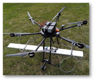
NETL has been a pioneer in the use of small atomic magnetometers on drones. Magnetometers are scientific instruments used to measure the strength of a magnetic field. On land, for example, magnetometers can be used to find base and precious metals, which often occur in deposits that also contain magnetic minerals.
“Starting in 2005, NETL used magnetometers on helicopters to accurately search large areas for the presence of undocumented wells — wells that went into service in the early 20th century and predate modern regulations and record keeping,” explained Richard Hammack, NETL research group leader. When small, lightweight magnetometers became available in 2015, NETL transitioned from helicopter to drone magnetic surveys, which lowered the cost of well location surveys.
“Finding and documenting these wells, which are often unsealed, is crucial for addressing environmental effects of legacy resource development. We have also used drone-based LiDAR for well location in areas where the well casing was not magnetic. Since 2020, we’ve used drone-based magnetometers and electromagnetic sensors to map buried steel pipelines—some as small as two inches in diameter.”
NETL is also exploring the use of methane sensors on drones to detect methane emissions from abandoned wells.
In the future, Hammack said, the Lab plans to use sensitive three-component magnetometers on drones for semi-airborne electromagnetic surveys that continually map the expansion of the carbon dioxide (CO2) plume at storage locations.
Carbon storage in concert with hydrogen power derived from America’s abundant energy resources has been identified as a path forward in decarbonizing the economy to address climate change while also fueling the economy and providing new economic opportunities. Robust sensing capabilities using drones can help ensure maximum effect of CO2 storage sites and minimize costs.
“Currently, we are evaluating SQUID magnetometers on manned helicopters for semi-airborne electromagnetic surveys of carbon storage areas,” Hammack said. “The SQUID magnetometers are too heavy for small drone aircraft but smaller, lighter magnetometers with the required sensitivity are being developed.”
Short for superconducting quantum interference device, SQUID magnetometers are very sensitive and used to measure extremely subtle magnetic fields.
NETL is working with its industry partners, which are helping provide expertise in the design, execution and interpretation of electromagnetic surveys using a SQUID sensor at a field site in Kemper County, Mississippi..
With large injections just starting, it will take several years to show that the airborne survey is actually detecting the expanding CO2 plume boundaries, Hammack said. However, with improvements in flight duration and payload capacity, the potential for further development is enormous, with sensors mounted on autonomous airships being a possibility in the future
“In the future, I can see NETL using drone swarms — multiple drones with sensors in a coordinated flight plan — to gather data from multiple locations at the same time,” Hammack said. “We have investigated this for determining the location and conditions of pipelines, for example. Researchers are using drone swarms to determine the location and concentration of methane plumes around processing facilities.”
NETL is a U.S. Department of Energy national laboratory that drives innovation and delivers technological solutions for an environmentally sustainable and prosperous energy future. By leveraging its world-class talent and research facilities, NETL is ensuring affordable, abundant and reliable energy that drives a robust economy and national security, while developing technologies to manage carbon across the full life cycle, enabling environmental sustainability for all Americans.

