Business

Business
Explore the potential of the Fort Berthold Reservation and create a market to attract independent operators. Integration of remote sensing data to access exploration potential, taking maximum advantage of existing data availability, but also a relatively low-cost approach that will be readily applicable elsewhere. The Lake Sakakawea area of Fort Berthold reservation forms a large, continuous block attractive for development, which could benefit the Three Affiliated Tribes through jobs and royalty income.
Program
Project was in response to DOE's solicitation (DE-RP26-99BC13184, 1999) Applications of Petroleum Technologies on Native American and Alaskan Native Corporation properties for the benefit of the entire tribe/native corporation. The initiative seeks to stimulate economic development and increase oil and gas production on Native American lands while protecting the environment.
Advanced Resources International
Houston, TX
Three Affiliated Tribes
Fort Berthold Reservation, ND
Bureau of Indian Affairs
Lakewood, CO
The Three Affiliated Tribes-Mandan, Hidatsa and Arikara-have almost 600,000 acres of land in the Fort Berthold Reservation in North Dakota open for oil and gas exploration. The reservation lies close to the Nesson Anticline, a large oil producing structure in the southern Williston Basin. Approximately 40 MMbbl of oil have been identified on Tribal lands in Antelope Field.
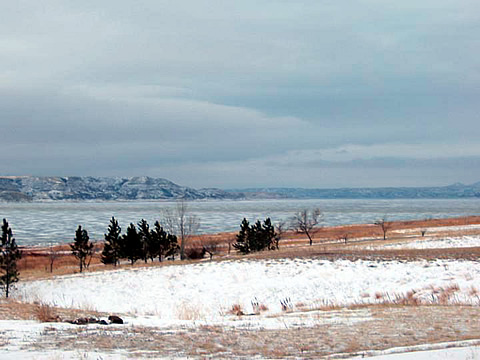
150,000 acres of Tribal lands lie beneath Lake Sakakawea, formed when the Army Corps of Engineers built a dam on the Missouri River in 1951. In the past ten years the lake and mineral rights under the lake were restored to Tribal ownership. Although 100 wells have been drilled on tribal lands, no wells have been drilled on Lake Sakakawea acreage, due to lack of knowledge about potential structures or delineation of prospects.
Project Results
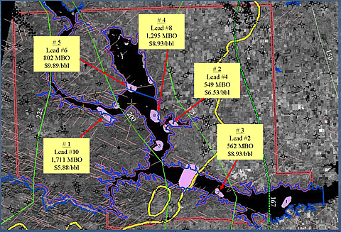
Eleven oil prospects under Lake Sakakawea have been identified using remote sensing technologies.
Benefits
The oil recovered from the Fort Berthold region will be a significant benefit to the Three Affiliated Tribes. If all are successful, the eleven leads identified are estimated to yield a total of 8.9 MMbbl of recoverable oil.
The integrated approach to surveying a large block of undeveloped land provides a method that other Tribes in the western U.S. may find useful for exploration of land that has only recently been turned over to them through Federal and State policies. The technologies for exploration and assessment of oil potential under bodies of water or areas where surface access is restricted by other factors provides opportunity for development using innovative horizontal drilling and completion methods.
Project Summary
Completed the analysis of all producing wells in or near the Fort Berthold reservation to compare and contrast potential for leads under Lake Sakakawea.
ARI developed an exploration strategy for Fort Berthold using 200 miles of seismic, Landsat and aeromagnetic data covering the area surrounding and beneath Lake Sakakawea. Geological analysis began with studies of surface lineaments using satellite imagery and high-resolution aeromagnetic data. Existing onshore data was reprocessed using improved methodology, and integrated with 200 miles of new seismic survey data. Well data from existing wells in Antelope Field producing from Madison Limestone and Bakken Shale provided data for geologic correlation, information on drilling and completion intervals, and estimates of well rates and recovery factors. Because the area of interest was under Lake Sakakawea, the use of onshore horizontal wells (to extend under the lake) were studied.
Seismic data and aeromagnetic depth maps were combined to image paleohighs revealing numerous seismic structures in the western portion of the Fort Berthold Reservation, including four previously unidentified basement shear zones. The structures are larger than typical Williston Basin Red River structures. Oil in Antelope Field accumulated in structural and stratigraphic traps in and around paleohighs. Ten promising structural prospects were generated by the combined seismic, aeromagnetic and Landsat surveys. These areas are all assessable using horizontal well technology. Oil potential was also identified based on stratigraphic mapping in the eastern portion of Lake Sakakawea. The 11 identified prospects may expect oil recovery ranging from 283,000 to 1.7 MMbbl each.
Horizontal wells in the southern Williston Basin cost $450,000 to $1 million, thus using all available data and resources to generate and analyze prospects is an important strategy.
(August 2004)
The project was completed in February 2004. Recommendations to the Three Affiliated Tribes included: 1) drill a test well at one or more of the prospects identified, 2) acquire an additional 300 miles of seismic survey lines that are available and integrate the data with the present survey and, 3) market the eleven prospects to independent operators.
ARI's detailed reservoir characterization of the Fort Berthold Tribal lands are currently being marketed to independent operators who may be willing to join with the Three Affiliated Tribes to develop the Lake Sakakawea area. To encourage oil and gas exploration and production and aid the Tribes, North Dakota is providing a special tax relief program to promote development on the reservation.
Publications
An electronic copy of the report detailing the study are available from NETL at 918-699-2000.
$3,298,000
$338,000 (53% of total)
NETL - Virginia Weyland (virginia.weyland@netl.doe.gov or 918-699-2041)
ARI - Scott Reeves (sreeves@adv-res-hou.com@usgs.gov or 713-780-3819 or 713-780-0815)