Business

Business
A primary goal of this project is to seismically delineate the non-linear movement of a miscible CO2 floodbank through a thin carbonate petroleum reservoir with sufficient resolution to identify reservoir heterogeneities and their influence on sweep uniformity and efficiency.
University of Kansas Center for Research, Lawrence, KS
Kansas Geological Survey, Lawrence, KS
Time-lapse 3-D, or 4-D, seismic reflection profiling has proven an effective tool during the past decade to evaluate the effectiveness of conventional EOR programs. Consistency and repeatability of 3-D surveys have been the most persistently identified problems associated with time-lapse monitoring of reservoir production. Seismic monitoring has been considered viable only for the most prolific fields, which possess the greatest potential for significant returns with the identification of stranded reserves. The vast majority of Midcontinent reservoirs would not be considered candidates for 4-D monitoring using historical criteria.
The potential of seismically monitoring the injection of miscible CO2 into thin carbonate reservoirs only recently has been studied. Field tests to date of this technique have used conventional approaches without significant regard to the economics of routine application or spatial and temporal sampling necessary for application to most Midcontinent reservoirs. Changes in reservoir characteristics between baseline and one—or at most two—monitoring surveys have previously assumed linearity and have not been designed to be incorporated into the production scheme.
Results
The efficiency of enhanced oil recovery (EOR) programs relies heavily on accurate reservoir models. Movement of miscible carbon dioxide (CO2) injected into a thin (~5 m), shallow-shelf, oomoldic carbonate reservoir around 900 m deep in Hall-Gurney field in Russell County, KS, was successfully monitored using high-resolution 4D/time-lapse seismic techniques. Use of an unconventional approach to acquisition and interpretation of the high-resolution time-lapse/4D seismic data was key to the success of this monitoring project.
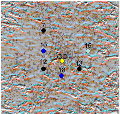
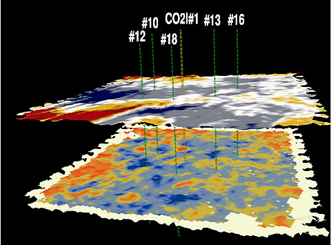
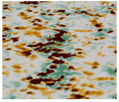
Differences interpreted on consecutive time-lapse seismic horizon slices are consistent with CO2 injection volumetrics, match physical restraints based on engineering data and model amplitude response, and honor production data. Textural characteristics in amplitude envelope images appear to correspond to non-uniform expansion of the CO2 through the reservoir, honoring both the lineaments identified on baseline data and changes in containment pressures. Interpretations of a set of time-lapse seismic images can be correlated to a mid-flood alteration of the injection/production scheme intended to improve containment and retard excessive northward movement of the CO2. Imaging of CO2 resulted in timely adjustments in flow-simulation models and highlighted previously unforeseen lineament control on reservoir-fluids flow.
Benefits
Continued success seismically monitoring CO2 movement through this reservoir will reveal critical components and considerations necessary for routine incorporation of 3-D high-resolution seismic monitoring with CO2 EOR programs in thin, relatively shallow, mature carbonate reservoirs. Changes in production schemes made possible by incorporating nearly real-time monitoring data into CO2 injection EOR programs could dramatically impact both the efficiency and economics of that technology in many Midcontinent fields. Refinements to 3-D high-resolution reflection imaging coming from this study also could provide assurances essential for routine sequestration of CO2 in depleted oil/gas reservoirs or brine aquifers. Survey-to-survey time sampling in this time-lapse study enabled better understanding of the rate of CO2-plume progression under supercritical conditions in carbonates and provided better insight into significance of incorporating seismically imaged lithofacies and lineaments in future CO2-injection pattern designs.
Summary
This project is designed to address questions related to both EOR CO2 flood management and CO2 sequestration in mature, shallow, and thin carbonate reservoirs. Important aspects related to flood management include delineating preferential CO2 pathways, enhancing sweep efficiency, locating areas of bypassed oil, and defining the mechanisms controlling CO2 movement. As a secondary component, accessing the feasibility of this methodology for applications in CO2 sequestration includes identifying preferential pathways for CO2 movement, delineating features that might influence long-term containment of CO2, detecting movement of CO2 outside containment at high enough resolution to provide the necessary public assurances, and defining the minimum survey requirements for effective long-term monitoring.
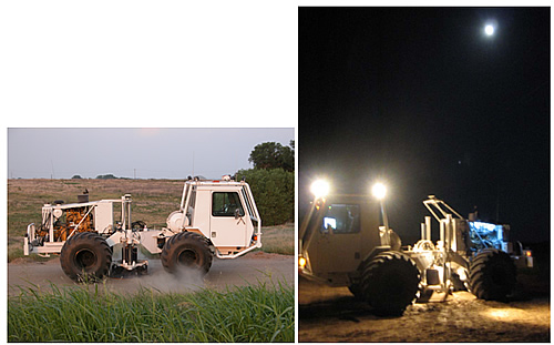
Twelve 3-D seismic reflection surveys were planned to be conducted over a 6-year time window to develop and refine appropriate methodologies for monitoring the injection and containment of miscible CO2 in a thin carbonate reservoir in central Kansas. With funding available for only the first 3 years, significant processing and interpretation refinements could not be developed and implemented. Currently, the nine 3-D surveys already acquired have been preliminarily (brute) processed and used in designing basic fluid simulations.
Seismic data acquisition and preliminary processing on the nine 3-D reflection surveys (one baseline and eight monitor) has been completed within 3 years. This work includes the following highlights:
Several unique approaches to data equalization have allowed differencing and interpretations consistent with previous approaches, enhancing confidence in the image and growth pattern suggested from preliminary processing and interpretations. These efforts include the following highlights:
Time-lapse seismic monitoring of CO2 revealed weak anomalies in these thin carbonates well below temporal resolution and were successful with moderate cross-equalization and elevated attention to consistencies in acquisition and processing. Most notably, methods applied here avoid the complications associated with inversion-based attributes and extensive cross-equalization techniques.
Distribution and geometries associated with similar seismic facies and seismic-lineament patterns are suggestive of a complex ooid shoal depositional motif, an interpretation consistent with an oolitic lithofacies reservoir type. Oolitic facies are imaged on these seismic data at a resolution significantly greater than previously documented.
(December 2008)
This project has been completed and the final report is listed below under "Additional Information".
Funding
This project was selected from submissions to DOE’s sole-source proposals program.
$2,304,327
$577,529 (20% of total)
NETL – Chandra Nautiyal (chandra.nautiyal@netl.doe.gov or 918-699-2021)
KGS - Rick Miller (rmiller@kgs.ku.edu, or 785-864-2091)
Final Project Report [PDF]
Publications (partial list)
KGS project website: http://www.kgs.ku.edu/Geophysics/4Dseismic [external site].
Raef, A.E., R.D. Miller, A.P. Byrnes, W.L. Watney, and E.K. Franseen, “3-D Seismic Imaging of Structural and Lithofacies Properties and Time-Lapse Monitoring of an EOR-CO2-Flood: Hall-Gurney Field,” Kansas, USA, accepted for presentation, 14th European Symposium on Improved Oil Recovery, Cairo, Egypt, April 22-24, 2007.
Raef, A.E., and R.D. Miller, “A non-differencing approach to seismic monitoring: Implications for difficult carbonate reservoirs,” Society of Exploration Geophysicists, New Orleans, LA, October 1-6. 2006.
Raef, A.E., R.D. Miller, A.P. Byrnes, W.E. Harrison, “Impact of improved seismic resolution and signal-to-noise ratio on monitoring pore-fluid composition changes: CO2-injection, Hall-Gurney Field, Kansas, USA,” Annual convention of the American Association of Petroleum Geologists, Houston, TX, April 9-12, 2006.
Raef, A.E., R.D. Miller, A.P. Byrnes, and W.E. Harrison, “Pore-fluid composition oriented 4D-seismic data processing and interpretation: implications for monitoring EOR and/or sequestration CO2,” AAPG Rocky Mountain Section Annual Meeting, Billings, MT, June 11-13, 2006.
Watney, W.L., E.K. Franseen, A.P. Byrnes, R.D. Miller, A.E. Raef, S.L. Reeder, and E.C. Rankey, “Characterization of Seismically Imaged Pennsylvanian Ooid Shoal Geometries and Comparison with Modern,” Annual convention of the American Association of Petroleum Geologists, April 9-12, 2006, Houston, TX; Annual Convention Abstracts Volume, p. 113.
Miller, R.D., A.E. Raef, A.P. Byrnes, and W.E. Harrison, “4-D seismic—Application for CO2 sequestration assurances” [abstract published online], AAPG Mid-Continent Section meeting, Oklahoma City, OK, September 10-13, 2005.
Raef, A.E., R.D. Miller, A.P. Byrnes, E.K. Franseen, W.L. Watney, and W.E. Harrison, “A new approach for weak time-lapse anomaly detection using seismic attributes: Geology and production data integrated monitoring of miscible EOR-CO2 flood in carbonates,” Society of Exploration Geophysicists, Houston, TX, November 6-11, 2005, pp. 2426-2429.