Business

Business
The objectives of this research are twofold: First, to investigate the feasibility of simultaneously inverting different types of geophysical data linked through a rock physics model to produce a single, self-consistent earth model parameterized by hydrologic parameters (porosity, fluid, and gas saturations, etc.) rather than geophysical parameters; second, if such inversion is feasible, to develop specific algorithms to use surface (land or marine) data and assess these algorithms in terms of parameter resolution and computational requirements.
Lawrence Berkeley National Laboratory (LBNL)
Berkeley, CA
Sandia National Laboratory
Sandia, NM
The fundamental problem in geophysical inversion is the underdetermined nature of the problem. Whether the objective is structural imaging or mapping reservoir fluid properties, the number of parameters, which control the geophysical response, is greater than the available degrees of freedom in individual geophysical data sets (seismic, electromagnetic [EM], gravity, etc.). For example, in 4-D reservoir monitoring, time-lapse changes in acoustic and elastic impedance are primarily functions of changes in pressure, water saturation, and gas saturation. Unfortunately, the changes in the acoustic and elastic (P and S) impedances do not uniquely map to changes in the reservoir parameters.
However, this ambiguity, or non-uniqueness, can be reduced and sometimes eliminated by incorporation of other geophysical data sets. In this example, EM data would provide independent estimates of water saturation changes, thus constraining the pressure and gas saturation changes estimated from the seismic data. Additional constraints can be provided by fine-scale geophysical measurements made in boreholes. The optimum technique for estimating structure and/or reservoir parameters must be capable of combining all available data in an integrated, self-consistent model. Self-consistent means that the geophysical parameters (velocity, conductivity, density) of the model, which fits the observed data, are all linked through a rock properties model that relates the geophysical parameters to the fluid parameters of the reservoir.
Project Results
The researchers have developed and demonstrated the first successful joint inversion algorithms for simultaneously modeling electromagnetic and seismic field data to produce a single consistent reservoir model of fluid saturations, pressure, and formation porosity. The work has been presented at several major international conferences, and a publication on the new algorithms has been accepted for publication in Geophysics in late 2005 or early 2006.
Benefits
This research will benefit any effort to quantitatively estimate reservoir parameters from geophysical data by providing an improved understanding of the complex interdependence between multiple reservoir parameters and the resulting geophysical parameters. This project has the potential to provide the first workable joint geophysical imaging codes to provide direct estimates of reservoir parameters from geophysical data.
Project Summary
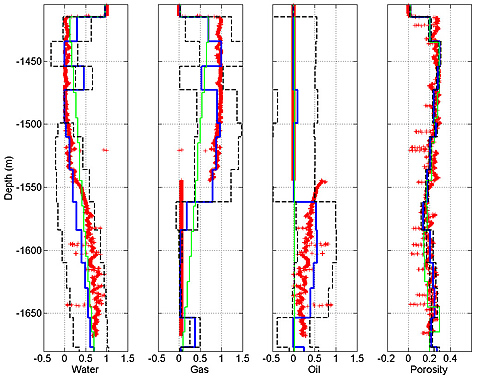
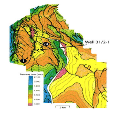
Accurate estimation of reservoir parameters from geophysical data is of utmost importance in hydrocarbon exploration and production. The project performers have developed a new joint inversion algorithm to directly estimate reservoir parameters using both seismic amplitude versus angle (AVA) and marine controlled-source electromagnetic (CSEM) data. The reservoir parameters are linked to the geophysical parameters through a rock-properties model. Errors in the rock-properties model parameters introduce errors of comparable size in the joint inversion reservoir parameter estimates. Tests of the concept on synthetic one-dimensional models demonstrate improved fluid saturation and porosity estimates for joint AVA-CSEM data inversion (compared with AVA or CSEM inversion alone). Comparing inversions of AVA, CSEM, and joint AVA-CSEM data over North Sea Troll field-at a location with well control- shows that the joint inversion produces estimated gas saturation, oil saturation, and porosity that is closest (as measured by the RMS difference, L1 norm of the difference, and net over the interval) to the logged values, whereas CSEM-only inversion provides the closest estimates of water saturation.
In summary, researchers have:
(June 2006)
The project is reaching the end of DOE funding. Researchers have negotiated new industry funding from ExxonMobil and ConocoPhillips. Other international companies (Norsk Hydro, Statoil) are negotiating to fund research in this area with LBNL.
$485,000
$400,000 (45% of total)
Other Government Organizations Involved: Sandia National Laboratory
NETL - Purna Halder (purna.halder@netl.doe.gov or 918-699-2083)
LBNL - Mike Hoversten (gmhoversten@lbl.gov or 510-486-5086)
Publications
Hoversten, G.M., Cassassuce, F., Gasperikova E., Newman G.A., , Chen J., Rubin, Y., Hou, Z., and Vasco D., Direct Reservoir Parameter Estimation Using Joint Inversion of Marine Seismic AVA & CSEM Data, accepted for publication in Geophysics, 2005.
Hoversten, G.M., Milligan, P., Byun, J., Washbourne, J., Knauer, L. C., Harness P., Crosswell electromagnetic and seismic imaging: An examination of coincident surveys at a steamflood project, Geophysics, 2003, 69, pp. 406-414.
Hoversten, G. M., Gritto, R., Washbourne, J., Daley, T. M., Pressure and Fluid Saturation Prediction in a Multicomponent Reservoir, using Combined Seismic and Electromagnetic Imaging, Geophysics, 2003, 68, pp. 580-1591.