Business

Business
The overall goals of this study are to 1) develop and demonstrate techniques and exploration methods never tried on the Leadville Limestone; 2) target areas for exploration; 3) increase deliverability from new and old Leadville fields through detailed reservoir characterization; 4) reduce exploration costs and risk, especially in environmentally sensitive areas; and 5) add new oil discoveries and reserves.
The project is being conducted in two phases, each with specific objectives. The objective of Phase 1 (Budget Period I) is to conduct a case study of the Leadville reservoir at Lisbon field (the largest Leadville producer) in San Juan County, UT, in order understand the reservoir characteristics and facies that can be applied regionally.
The first objective of Phase 2 (Budget Period II) is to conduct a low-cost field demonstration of new exploration technologies to identify potential Leadville oil migration directions (evaluating the middle Paleozoic hydrodynamic pressure regime and patterns in the regional water chemistry) and surface geochemical anomalies, especially in environmentally sensitive areas. The second objective is to determine regional facies (evaluating cores, geophysical well logs, and outcrop and modern analogs), identify potential oil-prone areas based on shows (using low-cost epifluorescence techniques), and target areas for Leadville exploration.
Utah Geological Survey (UGS), Salt Lake City, UT
Eby Petrography & Consulting, Inc., Denver, CO
Direct Geochemical, Golden, CO
ST Oil Company, Denver, CO
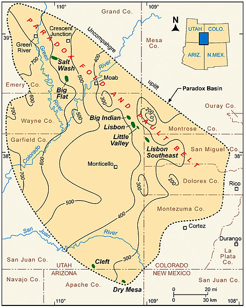
The Mississippian Leadville Limestone has produced over 53 million barrels of oil from six fields in the northern Paradox Basin region, referred to as the Paradox fold and fault belt, of Utah and Colorado. All of these fields are currently operated by independent producers. There have been no new discoveries since the early 1960s, and only independent producers continue to explore for Leadville oil targets in the region, 85 percent of which is under the stewardship of the federal government. This environmentally sensitive, 7,500 square-mile area is relatively unexplored, with only about 100 exploratory wells that penetrated the Leadville (less than one well per township), and thus the potential for new discoveries remains great.
Exploring for the Leadville Limestone is high-risk, with less than a 10 percent chance of success based on the drilling history of the region. Prospect definition requires expensive 3-D seismic acquisition, often in environmentally sensitive areas. These facts make exploring difficult for independents that have limited funds available to try new, unproven techniques that might increase the chance of successfully discovering oil.
Another problem in exploring for oil in the Leadville Limestone is the lack of published or publicly available geologic and reservoir information, such as regional facies maps, complete reservoir characterization studies, surface geochemical surveys, regional hydrodynamic pressure regime maps, and oil show data and migration interpretations.
The project is designed to address these issues and problems. All project maps, studies, and results will be publicly available in digital or hard-copy format and presented to the petroleum industry through a proven technology transfer plan.
Benefits
Project activities will reduce the risk taken by an independent producer in looking for Leadville oil, not only in exploring but in trying new techniques. For example, the independent would not likely attempt surface geochemical surveys without first knowing they have been proven successful in the region. If the project performers can prove geochemical surveys are an effective technique in environmentally sensitive areas, the independent will save both time and money exploring for Leadville oil.
Acquiring reservoir information or producing regional and reservoir characterization studies requires manpower resources that independents simply do not possess or normally have available only for drilling. The technology, maps, and studies generated from this project will help independents to identify or eliminate areas and exploration targets prior to spending significant financial resources on seismic data acquisition and environmental litigation and therefore increase the chance of successfully finding new accumulations of Leadville oil.
These benefits may also apply to other high-risk, sparsely drilled basins or regions where there are potential shallow-marine carbonate reservoirs equivalent to the Mississippian Leadville Limestone. A successful demonstration in the Paradox Basin makes it very likely that the same techniques could be applied in other basins as well.
Results
From Lisbon field core analysis, Leadville facies include open marine (crinoidal banks or shoals and Waulsortian-type buildups), middle shelf, and restricted marine (peloid and oolitic shoals). Rock units with open-marine and restricted-marine facies constitute a significant reservoir potential, having both effective porosity and permeability when dissolution of skeletal grains, followed by dolomitization, has occurred.
There are two basic types of dolomite: very fine, early dolomite and coarse, late dolomite. Early dolomitization preserves depositional fabrics, has limited porosity development—except for limited dissolution of fossils—and exhibits very low permeabilities. Most reservoir rocks within Lisbon field appear to be associated with the late type of dolomitization and associated leaching events, which may have developed from hydrothermal events that can greatly improve reservoir quality. The result can be the formation of large, diagenetic-type hydrocarbon traps.
The chemistry of both the Pennsylvanian and the Mississippian/Devonian brine systems changes from north to south through the length of the Paradox Basin, with the Pennsylvanian system brines having the higher total dissolved solids. This is probably due to their association with the bedded salts in the basin. The chemistry in both systems is dominantly NaCl, changing to brine whose cation content is greatly increased in calcium and to a lesser extent magnesium, and an anion content increasing in sulfate. Bicarbonate is very low in both brine systems.
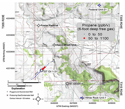
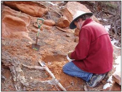
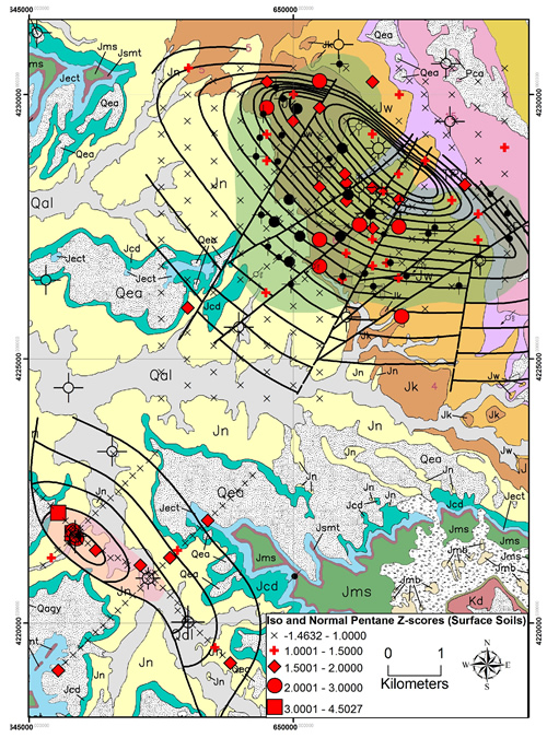
The main result of surface geochemical methods over the Lisbon and Lightning Draw Southeast fields is that certain low cost ($100 to $200 per sample), non-invasive geochemical methods are effective as pre-screening and follow-up tools in the exploration for Leadville hydrocarbon reservoirs. Hydrocarbon microseepage over the gas cap, oil leg, and water leg at Lisbon field is distinguished based on a linear combination of thermally desorbed hydrocarbons in surface soil samples, and outcrop fracture-fill soil and lichen samples. Both light and heavy aromatic hydrocarbon anomalies are evident in surface soils over the case-study fields. Fluorescence spectral patterns in anomalous areas are indicative of a weathered light oil or condensate. Narrow normal- and iso-alkane anomalies in the C2 to C6 range are evident in 6-foot-deep free gas samples over Lightning Draw Southeast field. Recommendations for future surface geochemical surveys for Leadville Limestone exploration in the Paradox Basin are (1) reconnaissance exploration should include the collection of surface soils (outcrop fracture-fill lichen and soils where applicable) for hydrocarbon and major/trace element analyses, and (2) anomalous areas identified in reconnaissance soil surveys should be followed up with the extraction and hydrocarbon analysis of deep free gas samples collected at short intervals (less than 300 feet). The short-interval free gas method is also recommended for testing existing seismic anomalies for hydrocarbon and carbon dioxide anomalies.
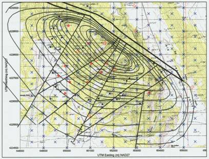
Hydrocarbon show maps of the highest average and highest maximum epiflourescence from regional well cuttings show a regional southeast-northwest trend of relatively high epifluorescence that parallels the southwestern part of the Paradox fold and fault belt while the northeastern part shows a regional trend of low epifluorescence. This implies that hydrocarbon migration and dolomitization were associated with regional northwest-trending faults and fracture zones, which created potential oil-prone areas along the southwest trend. As expected, productive wells (fields) are distinguished by generally higher epifluorescence.
The hydrodynamic analysis of the Leadville is based on drill stem test (DST) data shows two pressure trends one for the Mississippian (Leadville), and one for the Permian. The Pennsylvanian (Paradox reservoir) formations form a transition zone between these two trends. The Permian trend is hydrostatic appears to be controlled by the local ground water head (zero pressure intercept at about 4500 feet above sea level, whereas the Mississippian trend has a zero pressure intercept of about 3800 feet above sea level, and at sea level is almost 1000 psi below the Permian pressure trend. The Mississippian trend appears to be controlled by recharge from the Cataract Canyon stretch of the Colorado River near the northeast corner of the quadrant, where the Mississippian is less than 1000 feet below the river level.
The Mississippian Leadville Limestone was deposited as an open-marine, carbonate-shelf system highlighted with crinoid banks, peloid/oolitic shoals, and small Waulsortian mounds. These Mississippian environments have modern analogues in south Florida and the Bahamas. Understanding these facies and depositional patterns within the Paradox Basin and their modern analogs help to: (1) estimate reservoir heterogeneity and capacity, and (2) identify areas that have the greatest petroleum potential. In Florida Bsy and the Florida Keys, we studied transgressive depositional conditions and sediments across several facies belts ranging from the Everglades to shelf-edge barrier reefs, including supratidal algal flats, restricted marine mudbanks and “lakes,” tidal channels, and outer shelf sand bodies. Emphasis was placed upon two complementary facets of each environment: (1) the influence of physical and biological processes on the distribution of marine plants and animals, and (2) the relationship between the standing crop of organisms and the type of sediment and sedimentary textures produced in each environment. On Andros Island, Bahamas, we studied the origin, sedimentary dynamics, and reservoir properties of modern ooid shoals at Joulter’s Cay, and explored world-class carbonate tidal flats. All of these modern environments were extrapolated to Leadville Limestone examples observed in cores.
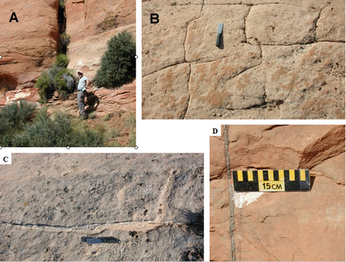
Utah is fortunate in that representative outcrop analogs (depositional or structural) for the Leadville Limestone are present along the south flank of the Uinta Mountains. These formations include the Madison, Gardison, and Deseret Limestones and are up to 600 feet thick. These production-scale analogs provide an excellent view, often in 3D, of reservoir petrophysics, facies characteristics, geometry, distribution, and the nature of boundaries contributing to the overall heterogeneity of reservoir rocks. The specific objectives of this work was to (1) increase understanding of vertical and lateral petrophysical and lithofacies variations within the Leadville reservoirs, (2) describe the lithologic characteristics, (3) determine the morphology, internal geometries, and possible permeability and porosity distributions, (4) identify potential impediments and barriers to fluid flow, and (5) determine the causes of brecciation features. The Madison Limestone is mostly light- to dark-gray, fine- to coarse-crystalline, cherty limestone. Dolomitic units are gray to tan, sucrosic to crystalline, and medium bedded with occasional silty partings. The Madison is generally thick to massive and unevenly bedded, forming vertical cliffs and dip slopes. Fossils include corals, brachiopods, crinoids, pelecypods, and gastropods. Observed depositional environments include tidal flat mud; oolitic shoal; shallow subtidal stable pellet/forams flats; deeper subtidal burrowed pellet muds; tidal flat mud; beach/foreshore; storm-dominated, outer shelf crinoid shoals; low energy, open marine muddy intershoal; low energy, and open marine outer shelf above storm wave base. Breccia associated with sediment-filled cavities is relatively common. These cavities are related to karstification of the exposed Leadville during Late Mississippian time. Post-burial brecciation is also quite common and is generally caused by natural hydrofracturing, creating an explosive-looking, pulverized rock. All of these lithofacies and breccia types are observed in Leadville cores from Lisbon field. The post-burial breccias are associated with the best reservoir development at Lisbon.
Summary
Because Lisbon field accounts for most of the Leadville oil production in the Paradox Basin, project researchers selected Lisbon as the major case-study field for Budget Period I. Because of excellent access over such a large oil accumulation, UGS also selected Lisbon field as the case study for the surface geochemical surveys as part of Budget Period II.
Researchers achieved the following milestones during Budget Period I:
Thus far during Budget Period II researchers have:
Technology transfer activities over the course of the project include:
(May 2009)
This project has been completed. The final report is available below under "Additional Information".
Funding
This project was selected in response to DOE’s Oil Exploration and Production solicitation DE-PS26-03NT15391-2 (February 2003), Advanced and Key Oilfield Technologies for Independents Program (Area 2—Exploration).
$267,828
$267,828 (50% of total)
NETL - Virginia Weyland (virginia.weyland@netl.doe.gov or 918-699-2041)
UGS - Thomas Chidsey, Jr. (tomchidsey@utah.gov or 801-537-3364)
Final Project Report [PDF-39.4MB]
Publications
Chidsey, T.C., Jr., Morgan, C.D., McClure, K., and Eby, D.E., “The Mississippian Leadville Limestone exploration play, Utah and Colorado,” abstract, American Association of Petroleum Geologists, Rocky Mountain Section Meeting, Official Program Book, 2004, p. 94.
Eby, D.E., Chidsey, T.C., Jr., Humphrey, J.D., and Taylor, L.H., “Dolomitization of the Mississippian Leadville reservoir at Lisbon field, Paradox Basin, Utah,” abstract, Rocky Mountain Association of Geologists Hydrothermal Dolomite Symposium and Core Workshop Program, 2004, pp. 31-32.
Chidsey, T.C., Jr., “The Mississippian Leadville Limestone exploration play, Utah and Colorado,” Rocky Mountain Association of Geologists, The Outcrop, 2004,V. 53, No. 10, pp. 1 and 6.
Eby, D.E., Chidsey, T.C., Jr., Morgan, C.D., McClure, K., Humphrey, J.D., Moore, J.N., Taylor, L.H., and Weyland, V.H., “Dolomitization of the Mississippian Leadville reservoir at Lisbon field, Utah,” abstract, 2005 American Association of Petroleum Geologists Annual Convention, Official Program with Abstracts, V. 14, p. A40.
Chidsey, T.C., Jr., Eby, D.E., Morgan, C.D., McClure, K., Moore, J.N., and Humphrey, J.D., 2005, “Dolomitization of the Mississippian Leadville Limestone, Paradox Basin, southeastern Utah,” abstract, 2005, Geological Society of America, Abstracts with Programs, V. 37, No. 7, paper 4-12.
Six Semi-Annual Technical Progress Reports, U.S. Department of Energy, DOE/BC15424-1-4.
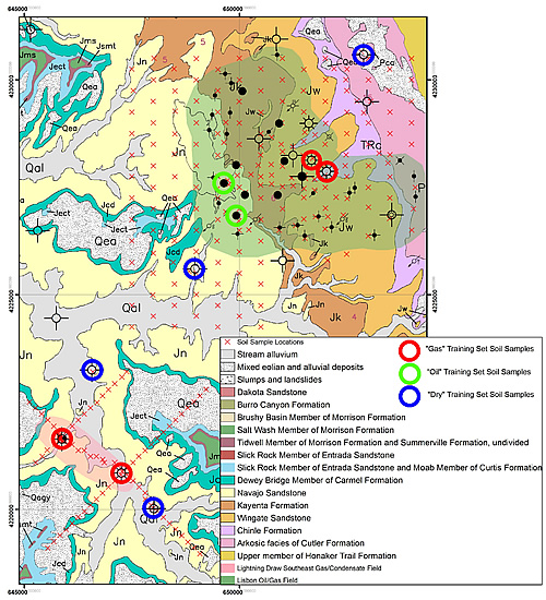
![Sampling grid for the surface geochemical survey over Lisbon and Lightning Draw Southeast fields, San Juan County, UT. Red X’s represent sample locations. About 270 shallow soil samples were collected at 1,500-foot intervals over an area of 16 square miles at Lisbon and along northwest-southeast and northeast-southwest grid lines at Lightning Draw Southeast. During the initial phase of the survey, 135 samples were collected around selected gas, oil, and dry wells over the gas caps, oil leg (present only at Lisbon), and water legs of the fields (10 to 15 samples at each of 10 wells [large blue circles]). Base map: La Sal 30X60’ topographic quadrangle map, U.S. Geological Survey.](/sites/default/files/inline-images/15424_LisbonMap.jpg)